Murray Mouth
| Murray mouth | |
|---|---|
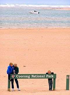
 The narrow Murray Mouth in the background as viewed from Hindmarsh Island, November 2006 | |
| Location | Australia |
| Coordinates | Coordinates: 35°35′00″S 138°53′00″E / 35.583333°S 138.883333°E |
| River sources | Murray River |
| Basin countries | Australia |
| Average depth | 2.4 metres (7 ft 10 in) as of 1985[1] |
Murray Mouth is the point at which the River Murray meets the Southern Ocean. The Murray Mouth's location is changeable. Historical records show that the channel out to sea moves along the sand dunes over time. At times of greater river flow and rough seas, the two bodies of water would erode the sand dunes to create a new channel leaving the old one to silt and disappear.
Description
The mouth of the Murray River is located about 10 kilometres (6.2 mi) south east of Goolwa and about 75 kilometres (47 mi) south south-east of the Adelaide city centre. The mouth is an opening in the coastal dune system which separates the river system from the ocean and which extends from near Goolwa in a south-easterly direction along the continental coastline for about 145 kilometres (90 mi). The mouth divides the dune system into two peninsulas. The peninsula on the west side is Sir Richard Peninsula which terminates at the mouth with a point named Pullen Spit. The peninsula on the east side is Younghusband Peninsula which terminates at the mouth with a point known in some sources as Sleepy Hollow.[2][3][1][4][5][6]
Water flows throughout the mouth from two directions. Firstly, the flow from the west passes along a passage known as the Goolwa Channel which is bounded by Hindmarsh Island to its north side. Secondly, the flow from the east passes along a passage known as the Coorong Channel. The Coorong Channel itself is fed by the Mundoo Channel which passes between Hindmarsh Island and Mundoo Island to the north, and by the Tauwitchere Channel to the east.[2][4]
Natural history
The Murray River became dammed by uplift of over 250 metres (820 ft) in the Grampians in Victoria during the Pleistocene about 2.5 Mya. The dam formed Lake Bungunnia, which reached 40,000 square kilometres (15,000 sq mi) and deposited the Blanchetown Clay therein.[17] Higher rainfall of at least 500 millimetres (20 inches) per year kept the lake filled at first, but during later times, rainfall was insufficient, and saline lakes formed, depositing dolomite. Even today, some saline lakes remain as a remnant of the vast lake.[18] The Murray River carved out a new path to the sea via Murray Bridge, replacing its previous exit at Portland, Victoria. The lake was gone by about 0.7 Mya.
History
European discovery and use
During 19th century with the discovery of gold, and the development of sheep and wheat farming along the Murray and its tributaries, the river became a major thoroughfare for the carriage of goods and produce. During the peak period of Murray River commerce (roughly 1855 to 1920) and before the development of rail and road transport, the Murray Mouth with its complex and unpredictable interaction between shallow, shifting and variable currents and the open sea, presented a major impediment to traffic between Adelaide and the Murray settlements, and many vessels foundered or were wrecked there.
Water flow

River Murray water is used by farmers for irrigation in four of Australia's states, as well as supplying water to most towns along the river, and many further away through various pipelines. It has been widely accepted that too much water is being extracted; however business and political concerns make it difficult to remedy the problem. A visible symptom of the over-extraction of river water is the closing of the Murray Mouth.
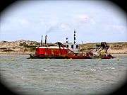
From October 2002 until 2010 dredging machines operated at the Murray Mouth.[7] Between 2002 and 2006, two machines operated moving sand from the channel to maintain a minimal flow from the sea and into the Coorong's lagoon system. [7] Without the 24-hour dredging, the mouth was at risk of becoming silted and closing, cutting the supply of fresh seawater into the Coorong, which would then warm up, stagnate and die. [7]
In mid-2006 the dredging was scaled back as a result of the improved conditions at the mouth. Now only one dredging machine operates, and permission was granted to one commercial operator to navigate the channel between Goolwa and the Coorong, passing the mouth. This operation finished in 2010. [7]
Dredging was scheduled to resume in January 2015. [7]
Protected area status
Australian government
The Murray mouth is immediately adjoined on its northern and eastern sides by the boundary of the Coorong and Lakes Alexandrina and Albert Wetland Ramsar site.[8]
South Australian government
The Murray mouth is located within a special purpose area within the Encounter Marine Park and is immediately adjoined on its northern and eastern sides by the boundary of the Coorong National Park.[9][10]
Non-statutory arrangements
The Murray mouth is adjoined on its northern and eastern sides by the boundary of the Coorong Important Bird Area which is an area considered by Birdlife International to be a place of ‘international significance for the conservation of birds and other biodiversity.’[11][12]
Citations and references
Citations
- 1 2 DMH, 1985, Chart 8
- 1 2 BIA, 2005, page 27
- ↑ DMH, 1985, Chart 7
- 1 2 DMH, 1985, Chart 9
- ↑ "Pullen Spit". Gazetteer of Australia online. Geoscience Australia, Australian Government.
- ↑ "Sleepy Hollow". Gazetteer of Australia online. Geoscience Australia, Australian Government.
- 1 2 3 4 5 http://www.naturalresources.sa.gov.au/samurraydarlingbasin/projects/all-projects-map/keeping-the-murray-mouth-open
- ↑ "Coorong and Lakes Alexandrina and Albert Wetland Ramsar site" (PDF). Department of Environment Water and Natural Resources. 28 January 2014. Retrieved 19 January 2015.
- ↑ DEWNR, 2012, page 2 of 6
- ↑ "Coorong National Park - Goolwa Barrage to Long Point Map" (PDF). Department of Environment, Water and Natural Resources. Retrieved 29 July 2015. }
- ↑ "Important Bird Areas factsheet: Coorong". BirdLife International. Retrieved 19 January 2015.
- ↑ "Sites - Important Bird and Biodiversity Areas (IBAs)". BirdLife International. Retrieved 19 January 2015.
References
- Boating Industry Association of South Australia (BIA); South Australia. Department for Environment and Heritage (2005), South Australia's waters an atlas & guide, Boating Industry Association of South Australia, ISBN 978-1-86254-680-6
- South Australia. Department of Marine and Harbors (DMH) (1985), The Waters of South Australia a series of charts, sailing notes and coastal photographs, Dept. of Marine and Harbors, South Australia, ISBN 978-0-7243-7603-2
- "Encounter Marine Park Management plan summary" (PDF). Department of Environment, Water and Natural Resources (DEWNR). 2012. Retrieved 17 June 2014.
Further reading
- South Coast Story, John C Tolley, Rowett Print, Mt Compass SA, 1968 ISBN 0-9587964-3-2