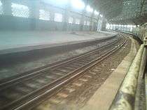
Mundagakanniamman Koil railway station
Mundagakanniamman Koil
முண்டகக்கண்ணியம்மன் கோவில் |
|---|
|
Chennai MRTS station |
|
|
| Platforms |
2 side platforms |
|---|
| Tracks |
2 |
|---|
| Construction |
|---|
| Structure type |
Elevated |
|---|
| History |
|---|
| Opened |
14 May 2014 |
|---|
| Services |
|---|
|
|
Mundagakanniamman Koil station is a railway station on the Chennai MRTS, located near Brindavan Street and Mundakakanni Amman Koil Street in Mylapore, along the Buckingham Canal. The station exclusively serves the Chennai MRTS, and serves the neighbourhood of northern Mylapore, Santhome and Royapettah.
History
Mundagakanniamman Koil station is the 18th MRTS station to be operational.[1] Work on the station began in 2002, at an initial estimated cost of ₹ 85.5 million.[2] The station has been built as an additional one in the first phase of the Chennai MRTS network completed much earlier. Initially slated to be completed in April 2009 at a cost of ₹ 350 million,[3] the construction was delayed due to land-acquisition issues. The next deadline was set as 2012 and again it was delayed due to getting approval for the name. The cost of construction was ₹ 100 million.[4][5] The station was opened to public on 14 May 2014.
Controversy in station's name
The station had been courting controversy ever since it was first slated to be completed in 2009. The construction cost had run to ₹ 100 million.[6]
The station's name ran into controversy in June 2013 when over 80 per cent work was over, since some local residents opposed the christening of the station after the Hindu goddess Mundagakanniamman. A temple of Goddess Mundagakanniamman is almost in the vicinity of the station, which covers Ganeshapuram and Slatterpuram that have a good number of Christian and Muslim population. The station's name boards were whitewashed by some residents, and the inauguration of the station, which was earlier scheduled for 15 May 2013, was deferred indefinitely. Later the Tamil Nadu government decided to retain the name since the station is located on the very street where the temple is situated, and the station was named "Mundagakanniamman Koil."[7][8]
Structure
The station is an elevated one built on the banks of the Buckingham Canal like most other MRTS stations. The station building consists of 2,400 sq m of parking area in its basement.[1] The design of the station is similar to that of the Thirumailai station. The station has only one entrance as the Buckingham canal runs alongside.[4]

Mundagakanniamman Koil MRTS station under construction as seen from an MRTS train
References
|
|---|
| | |
|---|
| | Early history (pre-1500) | |
|---|
| | Colonial period (1500–1900) | |
|---|
| | Modern period (1900–present) | |
|---|
| | Writers and historians | |
|---|
| | | |
|---|
| | Regions | |
|---|
| | Rivers and waterways | |
|---|
| | Lakes | |
|---|
| | Islands | |
|---|
| | Zoological parks | |
|---|
| | Reserve Forests | |
|---|
| | Marshlands | |
|---|
| | Heritage monuments | |
|---|
| | Statues | |
|---|
| | Memorials | |
|---|
| | | | | |
|---|
| | Business districts | |
|---|
| | SEZ | |
|---|
| | Companies and institutions | |
|---|
| | Industry | |
|---|
| | | | | | | |
|---|
| | Air | |
|---|
| | Sea | |
|---|
| | Rail | |
|---|
| | Road | Roads and
expressways | |
|---|
| Grade separators
and flyovers | |
|---|
| | Others | |
|---|
|
|---|
| | | | | | | Localities |
|---|
| | North | |
|---|
| | West | |
|---|
| | Central | |
|---|
| | South | |
|---|
| |
-
 Category Category
-
 Portal Portal
-
 WikiProject WikiProject
|
|
|
|---|
| Companies and
organisations | Transport for
Chennai | |
|---|
| | Bus operators | |
|---|
| | Train operators | |
|---|
| | Others | |
|---|
|
|---|
| | Airports | |
|---|
| | Rail Transport | |
|---|
| | Roads | |
|---|
| | Water/Sea Transport | |
|---|
| |
|
|
|---|
| | Bus Transportation | |
|---|
| | Intra-city Expressways | |
|---|
| | Rail Transportation | |
|---|
|
- * Planned
- † Under construction
|
|
|
|---|
| | Transport by cities | | |
|---|
| | Road | | National Highways | |
|---|
| | State Highways | |
|---|
| | Other Roads | |
|---|
| | Public Transport | |
|---|
|
|---|
| | Rail | | Rail Networks | |
|---|
| | Rail Stations | |
|---|
|
|---|
| | Air | | International Airports | |
|---|
| | Domestic Airports | |
|---|
| | Military Bases | |
|---|
|
|---|
| | Water | |
|---|
|

