Muharraq Island
| Native name: <span class="nickname" ">جزيرة المحرق | |
|---|---|
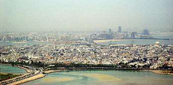
 Muharraq in the foreground; Manama on Bahrain Island in the background | |
 Muharraq Island (Bahrain) | |
| Geography | |
| Location | Persian Gulf |
| Coordinates | 26°16′01″N 50°38′18″E / 26.266941°N 50.638390°ECoordinates: 26°16′01″N 50°38′18″E / 26.266941°N 50.638390°E |
| Country | |
|
Bahrain | |
| Demographics | |
| Population | 110 964 (as of 2010) |
| Ethnic groups | Bahraini 62.4%, non-Bahraini 37.6 |
Muharraq Island (Arabic: جزيرة المحرق), formerly known as Moharek,[1] is the third largest island in the archipelago of Bahrain after Bahrain Island and Hawar Island. It is named after Muharraq City, the former capital of Bahrain.
There are several towns and villages located on the Island, including:
- Al Muharraq
- Al Dair
- Arad, formerly a separate island of its own[1]
- Busaiteen
- Hidd
- Galali
- Halat Bu Maher
- Halat Nuaim (connected by road)
- Halat Seltah (connected by road)
- Samaheej
Bahrain International Airport and the Muharraq Airfield are also located on the island.
There are three causeways connecting Muharraq Island with Manama on Bahrain Island:
- Shaikh Hamad Bridge: From Muharraq City to Diplomatic Area
- Shaikh Isa bin Salman Causeway: From Muharraq City/Busaiteen to Diplomatic Area
- Shaikh Khalifa Bridge: From Hidd to Juffair
See also
References
Citations
Bibliography
- "Bahrein", Encyclopædia Britannica, 9th ed., Vol. III, New York: Charles Scribner's Sons, 1878, p. 240.
- "Bahrein Islands", Encyclopædia Britannica, 11th ed., Vol. III, Cambridge: Cambridge University Press, 1911, p. 212.
| ||||||||||||||
This article is issued from Wikipedia - version of the Thursday, December 17, 2015. The text is available under the Creative Commons Attribution/Share Alike but additional terms may apply for the media files.