Mount Danxia
| Danxia Range | |
|---|---|
| 丹霞山 | |
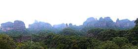
 View of some rocky outcrops of the range | |
| Highest point | |
| Coordinates | 25°1′55″N 113°44′46″E / 25.03194°N 113.74611°ECoordinates: 25°1′55″N 113°44′46″E / 25.03194°N 113.74611°E |
| Geography | |
 Danxia Range Location in China | |
| Location | Hunan, China |
| Parent range | Yuecheng Ridge, Nan Mountains |
| Official name | China Danxia |
| Type | Natural |
| Criteria | vii, viii |
| Designated | 2010 (34th session) |
| Reference no. | 1335 |
| State Party | China |
| Region | Asia-Pacific |
Mount Danxia (Chinese: 丹霞山; pinyin: Dānxiá Shān) is a noted scenic mountainous area near Shaoguan city in the northern part of Guangdong, People's Republic of China.
It is described on the local signage as a "world famous UNESCO geopark of China".
Description
The Danxia area is formed from a reddish sandstone which has been eroded over time into a series of outcrops surrounded by spectacular cliffs and many unusual rock formations known as Danxia landform. There are a number of temples located on the mountains and many scenic walks can be undertaken. There is also a river winding through the mountains on which boat trips can be taken.
Rock formations
Among other attractions that make the Danxia range interesting, the area has the following characteristic stone formations:
- Yang Yuan Stone, (Yangyuan "male/father stone") bearing a remarkable resemblance to a phallus
- Yin Yuan Stone or Yinyuan hole, which somewhat resembles the female vulva.
- Breasts Stone, human breast-shaped rocky outcrops on a cliff hanging 30 m above the ground.[1]
- Sleeping Beauty, a rocky range resembling a sleeping maiden.[2]
World Heritage Site
In the 2010 UNESCO list of world heritage sites, Mount Danxia was recorded as a natural World Heritage Site as part of China's Danxia landform.[3]
Features
-

Yang Yuan Stone
-

Yin Yuan Stone
-
Red cliff
-
Craggy face
-

Shaoshi rocky summits
See also
- China Danxia
- List of World Heritage Sites in China
- List of mountain ranges in the world named The Sleeping Lady
- Sacred Mountains of China
References
- ↑ Guangdong - Danxia Mountain Pictures
- ↑ Danxia Range - Sleeping Maiden
- ↑ "China Danxia". UNESCO. August 1, 2010. Retrieved March 3, 2011.
External links
| Wikimedia Commons has media related to Mount Danxia. |
- Guangdong: Yangyuan Stone. Retrieved 2007-3-31.
- Guangdong: Yinyuan Hole. Retrieved 2007-3-31.
| ||||||||||||||||||||||||||||||||||