Mount Constitution
| Mount Constitution | |
|---|---|
|
View of Mount Baker from the summit of Mount Constitution | |
| Highest point | |
| Elevation | 2,399 ft (731 m) NAVD 88[1] |
| Prominence | 2,407 ft (734 m) [2] |
| Coordinates | 48°40′39″N 122°49′52″W / 48.677569028°N 122.831162383°WCoordinates: 48°40′39″N 122°49′52″W / 48.677569028°N 122.831162383°W [1] |
| Geography | |
| Location | Orcas Island, San Juan County, Washington, U.S. |
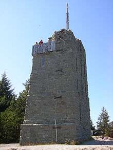
Mount Constitution is a mountain on Orcas Island, and the highest point in the San Juan Islands. A stone observation tower patterned after a medieval watch tower stands at the summit. It was designed by architect Ellsworth Storey and built by the Civilian Conservation Corps in 1936.[3] The tower offers panoramic views of the surrounding islands, the Cascade Mountains, and many Canadian and American cities. On a clear day, the view encompasses locations as diverse as Mount Baker, Mount Rainier, Saturna Island, and the cities of Vancouver, and Victoria, British Columbia. Mount Constitution lies within the 5,000 acres (20.2 km2) Moran State Park.
The prominence was named by Charles Wilkes during the Wilkes Expedition of 1838-1842 for the USS Constitution.[4]

References
- 1 2 "Constitution Reset". NGS data sheet. U.S. National Geodetic Survey.
- ↑ "Mount Constitution, Washington". Peakbagger.com.
- ↑ "HistoryLink.org- the Free Online Encyclopedia of Washington State History". www.historylink.org. Retrieved 2015-06-09.
- ↑ Majors, Harry M. (1975). Exploring Washington. Van Winkle Publishing Co. p. 23. ISBN 978-0-918664-00-6.
External links
![]() Media related to Views from Mt. Constitution at Wikimedia Commons
Media related to Views from Mt. Constitution at Wikimedia Commons
- "Mount Constitution". Geographic Names Information System. United States Geological Survey.
- "All Washington Peaks with 2000 Feet of Prominence". Jeff Howbert.