Bora Bora Airport
| Bora Bora Airport Aéroport de Bora Bora | |||||||||||||||
|---|---|---|---|---|---|---|---|---|---|---|---|---|---|---|---|
|
| |||||||||||||||
| IATA: BOB – ICAO: NTTB | |||||||||||||||
| Summary | |||||||||||||||
| Airport type | Public | ||||||||||||||
| Operator | SETIL - Aéroports | ||||||||||||||
| Serves | Bora Bora, French Polynesia | ||||||||||||||
| Location | Motu Mute | ||||||||||||||
| Elevation AMSL | 11 ft / 3 m | ||||||||||||||
| Coordinates | 16°26′37″S 151°45′09″W / 16.44361°S 151.75250°W | ||||||||||||||
| Runways | |||||||||||||||
| |||||||||||||||
| Statistics (2014) | |||||||||||||||
| |||||||||||||||
Bora Bora Airport (IATA: BOB, ICAO: NTTB), also known as Motu Mute Airport, is an airport serving the island of Bora Bora in French Polynesia. It is located on the islet of Motu Mute.[1]
The airport was opened in 1943, during World War II. Commercial service became available in 1958 after the runway was reconstructed. It is built on an island (the Polynesian word for which is "motu") located in a lagoon. A boat transfer is necessary to get to the main island of Bora Bora.[3]
Passengers from Vaitape, the largest population center on Bora Bora, usually use this airport for air travel.

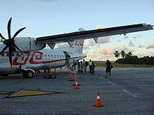
An Air Tahiti ATR72 boarding at Bora Bora Airport
Airlines and destinations
| Airlines | Destinations |
|---|---|
| Air Tahiti | Huahine-Fare, Manihi, Maupiti, Raiatea, Papeete, Rangiroa, Tikehau |
Air Tahiti serves flights from Bora Bora with late model 48-seat ATR 42 and 68-seat ATR 72 twin engine propjets.
References
- 1 2 NTTB – Bora Bora Motu Mute (PDF). AIP from French Service d'information aéronautique, effective 4 Feb 2016.
- ↑ Movements & passengers
- ↑ Bora Bora Airport at SETIL Aéroports
External links
- Aéroport de Bora Bora (Union des Aéroports Français) (French)
- Bora Bora Airport
- Airport information for NTTB at World Aero Data. Data current as of October 2006.
- Accident history for BOB at Aviation Safety Network
This article is issued from Wikipedia - version of the Monday, February 08, 2016. The text is available under the Creative Commons Attribution/Share Alike but additional terms may apply for the media files.