Moneton

The Moneton were a historical Native American tribe from West Virginia. In the late seventeenth century they lived in the Kanawha Valley, near the Kanawha and New Rivers.[1]
Name and language
| Moneton | |
|---|---|
| Native to | United States |
| Region | West Virginia |
| Extinct | late 17th century? |
|
Siouan
| |
| Language codes | |
| ISO 639-3 |
tta (as Tutelo) |
| Glottolog | None |
What the Monetons called themselves is unknown. In the 1670s, Abraham Wood wrote their name "Moneton" and as another variant, "Monyton."

The eastern slopes of the southern Allegheny Mountains in Virginia are traditionally known as the Mahock.[2] The Monetans are on the western rim of Tutelo and "Monasuccapanough" Siouan language groups, as well as Iroquois dialects
Researchers have speculated that the Moneton language was part of the Siouan family, close to Tutelo.[3]
History
James Mooney declared the Moneton lived in the western part of Colonial Virginia and said their name was an eastern Siouan word. Some scholars suggest Monetons were part of the Monacan, with the different names being a consequence of variable colonial spelling.
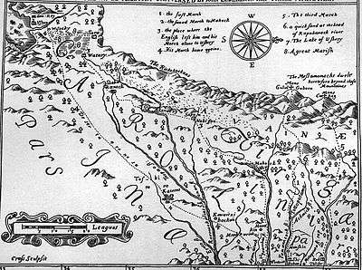
The First Explorations of the Trans-Alleghany Region by the Virginians 1650–1674
The word Monetons is Siouan,[4] though it may be Cherokee instead.[5] The Mohetan told Batts and Fallam that their villages were about halfway between Peters' Mountain and the Ohio River.[6] Hale and Mooney defines Siouan "Mon", "Ma" and "Man" as meaning a people's land. "Mone" has also been defined to mean water, and "ton" means large.[7][8] Doctor Rankin observed that the Tutelo of Virginia have closer linguistic ties to the Crows of Montana than to the Catawbans of Carolina. A recent study of nine thousand pottery shards from Fort Ancient sites in the Kanawha and Ohio River valleys showed that thirty seven percent of them bore corncob impressions similar to those produced in the Siouan villages of Virginia between 1400 and 1600.[9] Doctor Rankin concluded at the 2009 West Virginia Archaeology Annual Meeting that Siouan was probably spoken in the Kanawha Valley.
Using topographic maps, geographic landmarks and travel distances, Briceland[10] demonstrates that Batts and Fallam reached Matewan on the Tug Fork. The islands near Logan resembles the falls of the James River near Wood's Fort in Virginia, though the gravel bar near Matewan, West Virginia does not resemble these early descriptions of the village's location of Batts and Fallam.
Other inhabitants of the area

Another tribe known as the Tomahittons has been also been reported in the Ohio Valley. The reports from the Mohetan given to Batts and Fallam regarding this tribe correspond with reports from the Moneton to Arthur. Batts and Falla are credited as having discovered Kanawha Falls. Ouabano was a band of Mohicans or Eastern Lenape who lived within the region.[11] Earlier scholars have this site as found to be on Campbells Creek near Belle, West Virginia.[12]
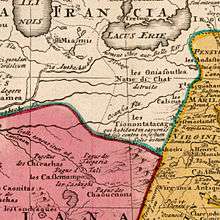
The Iroquois League, Huron Confederacy, and Andaste (Sultzman) are well reported as blocking the Nation du Chat from attaining fire arms. The Andaste served as middlemen to the French and Dutch trade, and the Dutch provided Andaste with fire arms.[13][14] Their neighbor to the east, in the Allegheny Mountains, were the Conestoga (Quaker for Andaste), earlier called Susquehannocks (Virginian). The Susquehannocks are first mentioned in the Voyages of Samuel Champlain for 1615, and he calls one of their some twenty villages "Carantouan". Carantouan was close to the New York and Pennsylvania border on the tributaries of the Susquehanna River on his map approaching towards the region from the Saint Lawrence Seaway.[15] Grant County, West Virginia, Hampshire County, West Virginia and Hardy County, West Virginia and Allegany County, Maryland[16] possess archaeological sites having Susquehannock Ceramics. A Susquehanna site is also located at Moorefield, West Virginia.
The tribes on the south eastern Allegheny Mountains of West Virginia in a region of the Blue Stone and Greenbrier river tributaries can be found in Batts and Fallows' September, 1671 Expedition.[17] The records the arrival of the Les Tionontatacaga or Guyandotte, named for the Guyandotte River in Cabell County. This journal does not identify the "Salt Village" on the Kanawha, but, that the Mehetan were associated with these sites, and may not have been associated with sites further down the Ohio River.
Protohistory

Anthropologist James B. Griffin concluded in 1942 that no historical evidence existed to indicate that Siouan speaking tribes resided there.[18][19] On the other hand, James Mooney, in a monograph surveying "The Siouan Tribes of the East," lists Mohetan as one of at least nine groups clearly Siouan.
"Calicuas" were reported at Cherokee Falls[20] (Valley Falls) in 1705.[21] Indian trader Charles Poke's trading post dates from 1731 with the remnant Calicuas of Cherokee Falls still in the region from the previous century. The Monetons may also be a distant Cherokee branch, partially evidenced by their antipathy for the Shawnees,[22]), who were located on both sides of the Ohio in the vicinity of the mouth of the Scioto River.[23]
See also
- History of West Virginia
- Prehistory of West Virginia
- Protohistory of West Virginia
- West Virginia Waterways
Notes
- ↑ Demallie 287
- ↑ [the name of the Kanawha on the Spanish map of Lopez y Cruz (1755), is given as "Tchalaquei" (the earliest Spanish form of "Cherokee", from the Choctaw, choluk, a hollow or cave); while'the Cherokee (now Tennessee) River itself is called "Rio de los Cherakis."] The Wilderness Trail (New York, 1911) Charles A. Hanna
- ↑ John Reed Swanton (1952). The Indian Tribes of North America. Genealogical Publishing Com. ISBN 978-0-8063-1730-4. Retrieved 6 November 2012.
- ↑ Mooney (letter of January 7, 1909).
- ↑ Fallum's journal.
- ↑ Clarence Walworth Alvord and Lee Bidgood, 1912.
- ↑ Robert Rankin, professor emeritus of linguistics at the University of Kansas, Siouan linguistics.
- ↑ "Kanawha Valley Fort Ancient people might be related to Sioux", By Rick Steelhammer Staff writer Gazette, November 7, 2009, SOUTH CHARLESTON, W.Va., WV Archaeology Interest Group, WVAS
- ↑ Rick Steelhammer summarized Darla Spencer of Cultural Resources Analysts, Inc.
- ↑ Briceland, Alan V. 1987 Westward from Virginia: The Exploration of the Virginia Carolina Frontier, 1650-1710. University of Virginia Press, Charlottesville. also
Briceland, Alan V. 1991 Batts and Fallam Explore the Backbone of the Continent. In Appalachian Frontier, edited by Robert D. Mitchell. - ↑ Hodge.
- ↑ Editor's Note: An example of the influx of the Moneton's region is found in the following quote in note: "The fight at the forks of the Pamunkey in 1656 in which Totopotamoi fell was really with the strange Ricahecrian Indians from beyond the mountains. The Rickahockans or Ricahecrians entered Virginia from beyond the mountains in 1656. Through misunderstanding and mismanagement they were attacked, and inflicted a severe defeat upon Colonel Edward Hill and the friendly Pamunkeys, at the forks of the river of that name. Neill, E. D. Virginia Carolorum, 245-246. The Bureau of American Ethnology identifies these Indians with the Cherokee [Mooney, Siouan Tribes of the East, also Handbook of American Indians, art. "Cherokee"]. They have also been identified with the Erie or Rique, who were defeated and expelled from their home on Lake Erie in 1655. [See Parkman, Jesuits in America, 438-441; Charlevoix, History of New France, vol. ii, 266.] They are referred to in many cases under the name "Riquehronnons" or "Rigueronnons"-Iroquois designations. [See Thwaites, Jesuit Relations, index s. v. "Eries;" Handbook of .American Indians, article "Erie", and synonyms.] They retired behind the Blue Ridge after defeating Hill, and remained there for several years.* Colonial Papers, Public Record Office, vol. xxiv; Winder Papers, Virginia State Library, vol. i, 252. Major William Harris is the same who accompanied Lederer on his second expedition. He received his rank in December, 1656, was Abraham Wood's subordinate in the Charles City County regiment, and is again mentioned in the militia records of that county, July 2, 1661. Hening, Statutes at Large, vol. i, 426; William and Mary Quarterly, vol. iv, 167-168."
Sir William Talbot's "The Discoveries of John Lederer" The First Expedition from the head of Pemaeoncock, alias York-River (due West) to the. top of the Apalataean Mountains
[Coxe's Account of the Activities of the English in the Mississippi Valley in the Seventeenth Century "A Memorial" by Dr. Daniel Coxe Report relative to the English discoveries in Carolina and Florida, and the settlement -of English and French claims (temp. George 1) : the writer Edward Billing"], The First Explorations of the Trans-Alleghany Region by the Virginians 1650- 1674" By Clarence Walworth Alvord and Lee Bidgood Published by The Arthur H. Clark Company, Cleveland, Ohio, 1912 - ↑ Erie, History. First Nations History, Lee Sultzman, (07/20/09)
- ↑ Editor Note: "Apparently some of the Neutrals were more closely attached to the Erie than the others, because both the Seneca and Huron often referred to both the Erie and Neutrals as the "Cat Nation." Sultzman, First Nations Histories
- ↑ Louise Welles Murray, Director, Tioga Point Museum, Athens, Pennsylvania, 1931
- ↑ Brashler 1987.
- ↑ From Annals of Southwest Virginia, 1769-1800. Lewis Preston Summers, Abingdon Virginia, 1929 (Pages 1-7) (4/10/2009)
- ↑ Abstract by Erin K. Smith, University of Central Florida (David Jones), quoting the abstract, "This article can be difficult to follow, as the author (Griffin) makes numerous references to individuals that were not introduced in the article. Also hindering reader comprehension are the many references to directions, routes, and locations, sometimes under multiple names, without aid of maps. The piece is composed largely of quotes, many from the eighteenth century, rendering it a difficult read."
- ↑ Griffin, James B., "On the Historic Location of the Tutelo and the Mohetan in the Ohio Valley." American Anthropologist April–June, 1942 Vol. 44 (2): 275-280.
- ↑ Wonderful West Virginia articles "Allegeny" and Wonderful W. Virginia September 1973, Pp.30, "Valley Falls Of Old", Walter Balderson
- ↑ Quoting from C. Gist journal 1753, November, "Thursday 15.—We set out, and at night encamped at George's Creek (near Fairfax Stone), about eight miles, where a messenger came with letters from my son, who was just returned from his people at the Cherokees, and lay sick at the mouth of Conegocheague (next major stream below Col Cresap's Fort Cumberland, upper Potomack River, Allegany Mountains.) --CHRISTOPHER GIST'S JOURNALS WITH HISTORICAL, GEOGRAPHICAL AND ETHNOLOGICAL NOTES AND BIOGRAPHIES OF HIS CONTEMPORARIES BY WILLIAM M. DARLINGTON [1815-1889] PITTSBURGH, J. R. WELDIN & CO., 1893. Also, In June, 1757, Captain Hamilton addressed Capt. Potter FORT LYTTLETON. Page 555-561. See Mr. Darlington's Map. There was a company of Cherokee Indians in King's pay, being at Fort Lyttleton, and Capt. Hamilton sent some of them to search along the foot of the Allegheny mountains to see if there were any signs of Indians on that route, and these Indians came upon Capt. Mercer, unable to rise; they gave him food, and he told them of the other; they took the captain's track and found him and brought him to Fort Lyttleton, carrying him on a bier of their own making. They took fourteen scalps on this expedition. Governor Morris directs E. Salter, April tenth, 1756: "When you get to Fort Lyttleton you will take upon oath what proofs you can of the certainty of Indian Isaacs having taken the scalp of Captain Jacobs, that he may be entitled to the reward."-- CLARENCE M. BUSCH. STATE PRINTER OF PENNSYLVANIA. 1896. Map: http://www.usgwarchives.org/pa/1pa/1picts/frontierforts/73edarlingtonmap.jpg The report: http://www.usgwarchives.org/pa/1pa/1picts/frontierforts/frontierforts.htm
- ↑ Foote Note: 'Showanoes' (Hodge) else Shanwans terminology of Vielle of Albany Expedition 1692~94 of the Albany, New England Fur Trade
- ↑ Chapter: "The Discovery of Kentucky" Pp. 125, "Register of Kentucky State Historical Society", By Kentucky Historical Society Published by The Society, 1922, Item notes: v.20 (1922) index:v.1-20 Original from Harvard University Digitized Jan 23, 2008
References
- Demallie, Raymond J. "Tutelo and Neighboring Groups." Sturtevant, William C., general ed. Raymond D. Fogelson, volume ed. Handbook of North American Indians: Southeast. Volume 14. Washington DC: Smithsonian Institution, 2004. ISBN 0-16-072300-0.
| ||||||||||||||||||||||||||||||||||||||||||||||||||