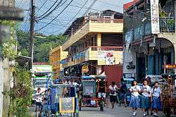
Mogpog, Marinduque
| Mogpog | ||
|---|---|---|
| Municipality | ||
 | ||
| ||
 Map of Marinduque showing the location of Mogpog | ||
.svg.png) Mogpog Location within the Philippines | ||
| Coordinates: 13°28′28″N 121°51′41″E / 13.47444°N 121.86139°ECoordinates: 13°28′28″N 121°51′41″E / 13.47444°N 121.86139°E | ||
| Country |
| |
| Region | MIMAROPA (Region IV-B) | |
| Province | Marinduque | |
| District | Lone district of Marinduque | |
| Founded | 1807 | |
| Barangays | 37 | |
| Government[1] | ||
| • Mayor | Senen Livelo Jr. (Liberal) | |
| • Vice Mayor | Rolando Mantala (Independent) | |
| • Sangguniang Bayan | ||
| Area[2] | ||
| • Total | 108.06 km2 (41.72 sq mi) | |
| Population (2010)[3] | ||
| • Total | 33,384 | |
| • Density | 310/km2 (800/sq mi) | |
| Time zone | PST (UTC+8) | |
| ZIP code | 4901 | |
| Dialing code | 42 | |
| Income class | 3rd class municipality[4] | |
| Patron Saint | Isidore the Laborer | |
| Website | mogpog.gov.ph | |
Mogpog is a third class municipality in the province of Marinduque, Philippines. According to the 2010 census, it had a population of 33,384 people.[3]
Barangays
Mogpog is politically subdivided into 37 barangays.[2] Hinanggayon was formerly a sitio of barrio (barangay) Argao; in 1954 it was elevated as a barrio.[5]
- Anapog-Sibucao
- Argao
- Balanacan
- Banto
- Bintakay
- Bocboc
- Butansapa
- Candahon
- Capayang
- Danao
- Dulong Bayan (Pob.)
- Gitnang Bayan (Pob.)
- Guisian
- Hinadharan
- Hinanggayon
- Ino
- Janagdong
- Lamesa
- Laon
- Magapua
- Malayak
- Malusak
- Mampaitan
- Mangyan-Mababad
- Market Site (Pob.)
- Mataas Na Bayan (Pob.)
- Mendez
- Nangka I
- Nangka II
- Paye
- Pili
- Puting Buhangin
- Sayao
- Silangan
- Sumangga
- Tarug
- Villa Mendez (Pob.)
The town center or poblacion comprises the barangays of Dulong Bayan, Gitnang Bayan, Market Site, Mataas na Bayan, and Villa Mendez.
History
In 1942, the Japanese troops occupied the town of Mogpog, Marinduque.
In 1945, in the Second World War the liberation of the town of Mogpog, Marinduque, the American and Filipino troops fought against the Japanese Imperial forces during the Battle of Marinduque.
Historically the famous Moriones Festival is said to have originated from Mogpog. Moriones Festival was founded by a Spanish friar Rev. Father Dionisio Santiago the first parish priest of mogpog. This festival is known to be one of the most colorful festivals in Marinduque and the Philippines. It is held in Mogpog and the surrounding areas of Marinduque island.
Demographics
| Population census of Mogpog | ||
|---|---|---|
| Year | Pop. | ±% p.a. |
| 1990 | 25,337 | — |
| 1995 | 28,201 | +2.03% |
| 2000 | 31,330 | +2.28% |
| 2007 | 33,341 | +0.86% |
| 2010 | 33,384 | +0.05% |
| Source: National Statistics Office[3][6] | ||
Landmarks

Barangay Balanacan is where the main shipping port is located. It is famous for its large image of Our Lady of Biglang Awa, erected at a top of a shed on a mound of land overlooking the sea.
Not far from the Academy is the town plaza, located at the side right of Marinduque Academy's Main Building, with a great view of a local park, the Municipal Building, and the Trial Court - all of which covers the town public market.
Educational institutions
Secondary
- Argao National High School
- Balanacan National High School
- Butansapa National High School
- Marinduque Academy (Barangay Gitnang Bayan)
- Mogpog NCHS
- Sayao National High School
- Quezon-Roxaz High School (poblacion)
Primary
- Argao Elementary School
- Balanacan Elementary School
- Bintakay Elementary School
- Bocboc Elementary School
- Butansapa Elementary School
- Capayang-Ino Elementary School
- Danao Public School
- Guisian Elementary School
- Hinadharan Public School
- Hinanggayon Elementary School
- Ino Primary School
- Lamesa Elementary School
- Laon Elementary School
- Magapua Elementary School
- Malayak Elementary School
- Mampaitan Public School
- Mendez Elementary School
- Mogpog Central School
- Nangka Elementary School
- Paye Elementary School
- Pili Elementary School
- Puting Buhangin Elementary School
- Sayao Elementary School
- Silangan Elementary School
- Sumangga Primary School
- Tarug Public School
Notable people from Mogpog
- Ricardo Jamin Cardinal Vidal, Archbishop emeritus of Cebu was born February 6, 1931, in Mogpog.
Twin towns/cities
-
 Makati, Philippines
References
- ↑ "Municipalities". Quezon City, Philippines: Department of the Interior and Local Government. Retrieved 5 February 2013.
- 1 2 "Province: MARINDUQUE". PSGC Interactive. Makati City, Philippines: National Statistical Coordination Board. Retrieved 5 February 2013.
- 1 2 3 "Total Population by Province, City, Municipality and Barangay: as of May 1, 2010" (PDF). 2010 Census of Population and Housing. National Statistics Office. Retrieved 2012-10-24.
- ↑ http://www.nscb.gov.ph/activestats/psgc/province.asp?provcode=174000000
- ↑ "An Act to Convert the Sitio of Hinangayon, Mogpog, Marinduque, into a Barrio to Be Known As the Barrio of Hinangayon". LawPH.com. Retrieved 2011-04-11.
- ↑ "Province of Marinduque". Municipality Population Data. LWUA Research Division. Retrieved 25 July 2013.
External links
| Wikimedia Commons has media related to Mogpog, Marinduque. |
 |
Tayabas Bay |  | ||
| Sibuyan Sea | |
Santa Cruz | ||
| ||||
| | ||||
| Boac |
| ||||||||||
