Mogami District, Yamagata

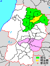
yellow & green - original extent in Meiji period
green - present area
pink - location in pre-Meiji period.
1. Kaneyama
2. Mogami
3. Funagata
4. Mamurogawa
5. Ōkura
6. Sakegawa
7. Tozawa
Mogami District (最上郡 Mogami-gun) is a rural district located in Yamagata Prefecture, Japan. As of August 2013, the district has an estimated population of 42,788 and an area of 1,508.54 km². All of the city of Shinjō was formerly part of Mogami District.
Towns and villages
History
Mogami County was an ancient place name in part of Dewa Province; however, it was located to the south of the present Mogami District, in an area corresponding roughly to modern Higashimurayama District and parts of Nishimurayama District.
Under the Tokugawa shogunate, much of the area of modern Mogami District was ruled as part of Shinjō Domain. Following the Meiji restoration it came under the new province of Uzen Province, which became part of Yamagata Prefecture in 1876. At that time, the area consisted of 2 towns and 86 villages. The area was organized as modern Mogami District in 1878.

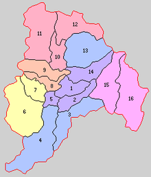
Purple - Shinjō-shi
1. Shinjō
2. Inafune
5. Yamuki
14. Hagino
Pink - Mogami-machi
15. Nishi-Oguni
16. Higashi-Oguni
Red - Mamurogawa-machi
10. Mamurogawa
11. Araki
12. Nozoki
Orange - Sakegawa-mura
8. Sakegawa
9. Toyosato
Yellow - Tozawa-mura
6. Furukuchi
7. Tozawa
Blue - areas which have remained unchanged
3. Funagata
4. Ōkura
13. Kaneyama
With the establishment of the municipality system on April 1, 1889, one towns (Shinjo) and 15 villages were established. Kaneyama was raised to town status on January 1, 1925 and Shinjō was raised to city status on April 1, 1949. Mamurogawa was raised to town status on April 1, 1950 and the towns of Mogami and Funagata were created on September 1 and December 1, 1954.
| ||||||||||||||||||||||||||||||||||||||||
Coordinates: 38°55′30″N 140°15′36″E / 38.92500°N 140.26000°E
|