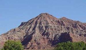
Moenkopi Formation

The Moenkopi is a geological formation that is spread across the U.S. states of New Mexico, northern Arizona, Nevada, southeastern California, eastern Utah and western Colorado. This unit is considered to be a group in Arizona. Part of the Colorado Plateau and Basin and Range, this red sandstone was laid down in the Lower Triassic and possibly part of the Middle Triassic, around 240 million years ago.[1]
History of investigation

There is no designated type locality for this formation. It was named for a development at the mouth of Moencopie Wash in the Grand Canyon area by Ward in 1901. In 1917 a 'substitute' type locality was located by Gregory in the wall of the Little Colorado Canyon, about 5 miles below Tanner Crossing in Coconino County, Arizona. While in the Great Basin, Bassler and Reeside characterized and named the Rock Canyon Conglomerate, Virgin Limestone, and Shnabkaib Shale members in 1921. Salt Creek (later replaced by Wupatki and Moqui Members) and the Holbrook Member were found and named in the Black Mesa basin by Hager in 1922. The Sinbad Limestone Member was named in the Paradox Basin by Gilluly and Reeside in 1928. Gregory named the Timpoweap Member in the Plateau sedimentary province in 1948. The Wupatki Member was first used in the Plateau sedimentary province and its age was modified to Early and Middle(?) Triassic by McKee in 1951. Contacts were revised by Robeck in 1956 and Cooley in 1958. The Tenderfoot, Ali Baba, Sewemup, and Pariott Members were named in the Piceance and Uinta Basins by Shoemaker and Newman in 1959. The Hoskinnini Member was assigned in the Black Mesa and Paradox basins by Stewart in 1959. Contacts were revised again by Schell and Yochelson in 1966. Blakey named the Black Dragon, Torrey, and Moody Canyon members in the Paradox Basin and Plateau sedimentary province in 1974. Contacts were revised yet again by Welsh and others in 1979. Kietzke modified the age to Early and Middle Triassic using biostratigraphic dating in 1988. The Anton Chico Member was assigned in the Palo Duro Basin and areal limits set by Lucas and Hunt in 1989. In 1991 areal limits were set again by Lucas and Hayden. An overview was completed by Lucas in 1991, Sprinkel in 1994, Hintze and Axen in 1995 and later, Huntoon and others.[2]
Members
Members are (in alphabetical order, asterisks (*) indicate usage by the U.S. Geological Survey, other usages by state geological surveys):[1]
- Ali Baba Member (CO,UT*)
- Anton Chico Member (NM)
- Black Dragon Member (UT)
- Holbrook Sandstone Member (AZ*)
- Hoskinnini Member (AZ*,CO*,UT*) or Hoskinnini Tongue (AZ*,CO*,UT*)
- Moody Canyon Member (UT)
- Moqui Member (AZ*)
- Pariott Member (CO*,UT*)
- Rock Canyon Conglomerate Member (AZ*,NV*,UT*)
- Sinbad Limestone Member (UT*)
- Sewemup Member (CO*,UT*)
- Shnabkaib Member (AZ*,NV*,UT*)
- Tenderfoot Member (CO*,UT*)
- Timpoweap Member (AZ,NV,UT*)
- Torrey Member (UT)
- Virgin Limestone Member (AZ*,NV*,UT*)
- Winslow Member (AZ)
- Wupatki Member (AZ*)
Places found
(6)-Rounded tan domes of the Navajo Sandstone, (5)-(dark)-layered red Kayenta Formation, (4)-cliff-forming, vertically-jointed, red Wingate Sandstone, (3)-slope-forming, purplish Chinle Formation, (2)-layered, lighter-red Moenkopi Formation, and (1)-white, layered Cutler Formation sandstone. Picture from Glen Canyon National Recreation Area, Utah.
Found in these geologic locations:[1]
- Black Mesa Basin*
- Great Basin province*
- Green River Basin*
- Las Vegas-Raton Basin
- Orogrande Basin
- Palo Duro Basin
- Paradox Basin*
- Piceance Basin*
- Plateau sedimentary province*
- San Juan Basin*
- Uinta Basin*
Found in these parklands (incomplete list):
- Grand Canyon National Park
- Capitol Reef National Park
- Zion National Park
- Monument Valley Navajo Nation Tribal Park
- Dinosaur National Monument
- Glen Canyon National Recreation Area
- Walnut Canyon National Monument
- Wupatki National Monument
Fauna

A diverse vertebrate fauna has been described from the Moenkopi Formation, mainly from the Wupatki Member and Holbrook Member of northern Arizona. Described basal vertebrates include freshwater hybodont sharks, coelacanths, and lungfish. Temnospondyl amphibians are a common component of the fauna. Temnospondyli include Eocyclotosaurus, Quasicyclotosaurus, Wellesaurus, Vigilius, and Cosgriffius. The rhynchosaur Ammorhynchus is known, but rare. Anisodontosaurus is an enigmatic reptile only known from a few tooth-bearing jaws. The poposauroid archosaur Arizonasaurus is known from one relatively complete skeleton and a significant amount of other isolated material. Footprints and several fragmentary body fossils are known from dicynodonts. The footprints of Cheirotherium and Rhynchosauroides are common in the Wupatki Member.
References
Works cited
- GEOLEX database entry for Moenkopi, USGS [Accessed 18 March 2006] (public domain text)
- Bibliographic References for Moenkopi [Accessed 18 March 2006]
Notes
- 1 2 3 GEOLEX database
- ↑ For the whole section, except where noted: GEOLEX database Bibliographic References