Modumudi
| Modumudi మోదుమూడి | |
|---|---|
| Village | |
 | |
 Modumudi Location in Andhra Pradesh, India | |
| Coordinates: 16°0′0″N 80°54′7″E / 16.00000°N 80.90194°ECoordinates: 16°0′0″N 80°54′7″E / 16.00000°N 80.90194°E | |
| Country |
|
| State | Andhra Pradesh |
| District | Krishna |
| Mandal | Avanigadda |
| Government | |
| • Type | Panchayat Raj |
| • Body | Gram panchayat |
| • MLA | Mandali Buddha Prasad |
| • MP | Konakalla Narayana Rao |
| Area[1] | |
| • Total | 13.76 km2 (5.31 sq mi) |
| Elevation | 11 m (36 ft) |
| Population (2011)[1] | |
| • Total | 4,256 |
| • Density | 310/km2 (800/sq mi) |
| Languages | |
| • Official | Telugu |
| Time zone | IST (UTC+5:30) |
| PIN | 521121 |
| Area code(s) | +91-8671-XXX XXX |
| Lok Sabha constituency | Machilipatnam |
Modumudi is a village panchayat located in the Krishna district of Andhra Pradesh state, India.
Transport

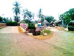
Modumudi Village
The nearest railway station to Modumudi is Repalle railway station which is located in and around 13.9 kilometer distance.
References
- 1 2 "District Census Handbook - Krishna" (PDF). Census of India. p. 16,472. Retrieved 8 February 2016.
This article is issued from Wikipedia - version of the Friday, February 12, 2016. The text is available under the Creative Commons Attribution/Share Alike but additional terms may apply for the media files.