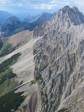
Mist Mountain
| Mist Mountain | |
|---|---|
 Mist Mountain from the south | |
| Highest point | |
| Elevation | 3,140 m (10,300 ft) [1] |
| Prominence | 487 m (1,598 ft) [2] |
| Coordinates | 50°33′15″N 114°54′34″W / 50.55416°N 114.90957°W [2] |
| Geography | |
| Location | Alberta, Canada |
| Parent range | Misty Range |
| Topo map | NTS 82J/10 |
| Climbing | |
| First ascent | 1946, Donald King, Alan Blayney, Len Blayney, York Blayney[1] |
| Easiest route | Hike, but avoid 'nameless ridge' |
Mist Mountain is a mountain located alongside Highway 40 in the Canadian Rockies of Alberta, Canada.
It reaches an elevation of 3,140 m (10,300 ft) and is visible from Alberta Highway 40 and the Sheep River.
The mountain was named in 1884 by George M. Dawson.[2]
See also
References
- 1 2 "Mist Mountain". PeakFinder.com. Retrieved 2007-08-31.
- 1 2 3 "Mist Mountain". Bivouac.com. Retrieved 2009-01-02.
External links
This article is issued from Wikipedia - version of the Sunday, January 19, 2014. The text is available under the Creative Commons Attribution/Share Alike but additional terms may apply for the media files.