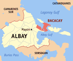
Bacacay, Albay
"Bacacay" redirects here. For the book, see Bacacay (book).
"Misibis Bay" redirects here. For the Philippine TV series, see Misibis Bay (TV series).
| Bacacay | |
|---|---|
| Municipality | |
 Map of Albay with Bacacay highlighted | |
.svg.png) Bacacay Location within the Philippines | |
| Coordinates: 13°18′N 123°48′E / 13.300°N 123.800°ECoordinates: 13°18′N 123°48′E / 13.300°N 123.800°E | |
| Country | Philippines |
| Region | Bicol (Region V) |
| Province | Albay |
| District | 1st district |
| Barangays | 56 |
| Government[1] | |
| • Mayor | Tobias B. Betito |
| Area[2] | |
| • Total | 122.13 km2 (47.15 sq mi) |
| Population (2010)[3] | |
| • Total | 65,724 |
| • Density | 540/km2 (1,400/sq mi) |
| Time zone | PST (UTC+8) |
| Zip Code | 4509 |
| Dialing code | 52 |
| Website | www.bacacay.gov.ph |
Bacacay is a second class municipality in the province of Albay, Philippines. According to the 2010 census, it had a population of 65,724.[3]
The current municipal mayor of Bacacay is Tobias Betito. He succeeded Mrs. Gloria Berango whose husband Atty. Eligio Berango has also been town mayor for 9 years. [4]
Tourism
Bacacay is a tourist place with caves and beaches. The town is visited most especially at summer due to many beautiful beaches. In fact, this is where the Kuron-Kuron Beach Resort, Viento de Mar Beach Resort, VRT (Tanchuling) Beach Resort, Michaelangelus Beach Resort, and the Misibis Beachfront Resort are found.
Barangays
Bacacay is politically subdivided into 56 barangays.[2]
- Baclayon
- Banao
- Bariw
- Basud
- Bayandong
- Bonga
- Buang
- Busdac (San Jose)
- Cabasan
- Cagbulacao
- Cagraray
- Cajogutan
- Cawayan
- Damacan
- Gubat Ilawod
- Gubat Iraya
- Hindi
- Igang
- Langaton
- Manaet
- Mapulang Daga
- Mataas
- Misibis
- Nahapunan
- Namanday
- Namantao
- Napao
- Panarayon
- Pigcobohan
- Pili Ilawod
- Pili Iraya
- Barangay 1 (Pob.)
- Barangay 2 (Pob.)
- Barangay 3 (Pob.)
- Barangay 4 (Pob.)
- Barangay 5 (Pob.)
- Barangay 6 (Pob.)
- Barangay 7 (Pob.)
- Barangay 8 (Pob.)
- Barangay 9 (Pob.)
- Barangay 10 (Pob.)
- Barangay 11 (Pob.)
- Barangay 12 (Pob.)
- Barangay 13 (Pob.)
- Barangay 14 (Pob.)
- Pongco (Lower Bogña)
- San Pablo
- San Pedro
- Sogod
- Sula
- Tambilagao (Tambognon)
- Tambongon (Tambilagao)
- Tanagan
- Uson
- Vinisitahan (Mainland)
- Vinisitahan-Napao (Island)
Demographics
| Population census of Bacacay | ||
|---|---|---|
| Year | Pop. | ±% p.a. |
| 1990 | 49,202 | — |
| 1995 | 56,295 | +2.56% |
| 2000 | 58,357 | +0.77% |
| 2007 | 61,574 | +0.74% |
| 2010 | 65,724 | +2.40% |
| Source: National Statistics Office[3][5] | ||
References
- ↑ "Municipalities". Quezon City, Philippines: Department of the Interior and Local Government. Retrieved 11 January 2013.
- 1 2 "Province: Albay". PSGC Interactive. Makati City, Philippines: National Statistical Coordination Board. Retrieved 11 January 2013.
- 1 2 3 "Total Population by Province, City, Municipality and Barangay: as of May 1, 2010" (PDF). 2010 Census of Population and Housing. National Statistics Office. Retrieved 10 January 2013.
- ↑ http://www.deped.gov.ph
- ↑ "Province of Albay". Municipality Population Data. LWUA Research Division. Retrieved 16 August 2013.
External links
| Wikivoyage has a travel guide for Bacacay. |
- http://www.deped.gov.ph/public/public.asp?sec=&pageno=1&keyword=&sort=&iwant2=®id=9&divid=59&schtype=Public&schlevel=1&keyword2=Bacacay
- Philippine Standard Geographic Code
- Philippine Census Information
- LGU Profile of Bacacay, Albay
 |
Lagonoy Gulf |  | ||
| Malilipot | |
Rapu-Rapu | ||
| ||||
| | ||||
| Santo Domingo | Albay Gulf |
| ||||||||||||||
This article is issued from Wikipedia - version of the Sunday, February 14, 2016. The text is available under the Creative Commons Attribution/Share Alike but additional terms may apply for the media files.