Metropolis of Lyon
| Metropolis of Lyon Métropole de Lyon | ||
|---|---|---|
| Metropolis | ||
| ||
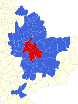
 Location of Metropolis of Lyon in France | ||
 The city (commune) of Lyon (in red) and 58 suburban communes (in blue) make up the Metropolis. | ||
| Coordinates: 45°45′27″N 4°51′14″E / 45.75750°N 4.85389°ECoordinates: 45°45′27″N 4°51′14″E / 45.75750°N 4.85389°E | ||
| Country | France | |
| Region | Auvergne-Rhône-Alpes | |
| Prefecture | Lyon | |
| Government | ||
| • President of the Metropolitan council | Gérard Collomb (PS) | |
| Area | ||
| • Total | 533.68 km2 (206.05 sq mi) | |
| Population (2012)37.4% in the communes of Lyon | ||
| • Total | 1,324,637 | |
| • Density | 2,500/km2 (6,400/sq mi) | |
| Time zone | CET (UTC+1) | |
| • Summer (DST) | CEST (UTC+2) | |
| Department number | 69M | |
| Arrondissements | 1 | |
| Cantons | none | |
| Communes | 59 | |
| Website |
www | |
The Metropolis of Lyon (French: métropole de Lyon), also known as Grand Lyon (i.e. "Greater Lyon"), is a French territorial collectivity (collectivité territoriale) with special status located in the central Eastern region of Auvergne-Rhône-Alpes, encompassing the city of Lyon and most of its suburbs.
It replaced the Urban Community of Lyon on January 1, 2015, in accordance with the MAPAM Law enacted in January of 2014.[1]
Communes
References
External links
- Metropolis of Lyon website (in French)
- The Greater Lyon official business website (in English)
| ||||||
This article is issued from Wikipedia - version of the Saturday, January 23, 2016. The text is available under the Creative Commons Attribution/Share Alike but additional terms may apply for the media files.