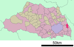
Matsubushi, Saitama
| Matsubushi 松伏町 | ||
|---|---|---|
| Town | ||
| ||
 Location of Matsubushi in Saitama Prefecture | ||
 Matsubushi Location in Japan | ||
| Coordinates: 35°56′N 139°49′E / 35.933°N 139.817°ECoordinates: 35°56′N 139°49′E / 35.933°N 139.817°E | ||
| Country | Japan | |
| Region | Kantō | |
| Prefecture | Saitama Prefecture | |
| District | Kitakatsushika | |
| Area | ||
| • Total | 16.22 km2 (6.26 sq mi) | |
| Population (July 1, 2012) | ||
| • Total | 31,145 | |
| • Density | 1,900/km2 (5,000/sq mi) | |
| Symbols | ||
| • Tree | Pine | |
| • Flower | Crysanthemum | |
| Time zone | Japan Standard Time (UTC+9) | |
| City Hall Address |
2424 Matsuboshi, Matsuboshi-machi, Kitakatsushika-gun, Saitama Prefecture, Japan 343-0192 | |
| Website |
www | |
Matsubushi (松伏町 Matsubushi-machi) is a town located in Kitakatsushika District, Saitama Prefecture, Japan.
As of 2012, the town has a population of 31,145 and a density of 1,900/km2 (4,900/sq mi).[1] The total area is 16.22 km2 (6.26 sq mi).[2] Matsubushi was formerly a center of rice production, but farmland is giving way to urbanization. The town now produces eggs, hakusai Chinese cabbage and negi, the Japanese welsh onion.[2] The town is home to the Matsubushi Campus of Taisho University.[3]
Matsubushi is also the birthplace of Shoto Tanemura, current Soke of the Genbukan World Ninpo federation.
References
- ↑ 松伏町の人口 [Population of Matsubushi] (in Japanese). Matsubushi, Saitama Prefecture: Town of Matsubushi. 2012. Retrieved July 9, 2012.
- 1 2 "松伏(町)" [Matsubushi]. Nihon Daihyakka Zensho (Nipponika) (in Japanese). Tokyo: Shogakukan. 2012. OCLC 153301537. Retrieved 2012-07-09.
- ↑ "松伏町" [Matsubushi]. Nihon Rekishi Chimei Taikei (in Japanese). Tokyo: Shogakukan. 2012. OCLC 173191044. dlc 2009238904. Retrieved 2012-07-09.
External links
 Media related to Matsubushi, Saitama at Wikimedia Commons
- Matsubushi official website (Japanese)
|
This article is issued from Wikipedia - version of the Sunday, November 08, 2015. The text is available under the Creative Commons Attribution/Share Alike but additional terms may apply for the media files.