Mardin Province
| Mardin Province Mardin ili | |
|---|---|
| Province of Turkey | |
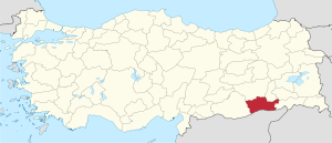
 Location of Mardin Province in Turkey | |
| Country | Turkey |
| Region | Southeast Anatolia |
| Subregion | Mardin |
| Government | |
| • Electoral district | Mardin |
| Area | |
| • Total | 8,891 km2 (3,433 sq mi) |
| Population (2010-12-31)[1] | |
| • Total | 744,606 |
| • Density | 84/km2 (220/sq mi) |
| Area code(s) | 0482 |
| Vehicle registration | 47 |
Mardin Province (Turkish: Mardin ili, Kurdish: Mêrdîn), is a province of Turkey with a population of 744,606. The population was 835,173 in 2000. The capital of the Mardin Province is Mardin (Syriac: ܡܶܪܕܺܝܢ "Mardin" in related Semitic language Arabic: ماردين, Mardīn). Located near the traditional boundary of Anatolia and Mesopotamia, it has a diverse population, composed of Kurdish, Arab and Assyrian people (who once made up the majority), with Kurds forming the majority of the province's population.[2]
History
Mardin comes from the Syriac word (ܡܪܕܐ) and means "fortresses".[3][4]
The first known civilization were the Subarian-Hurrians who were then succeeded in 3000BCE by the Hurrians. The Elamites gained control around 2230 BCE. and were followed by the Babylonians, Hittites, Assyrians, Romans and Byzantines.[5]
The local Assyrians/Syriacs, while very reduced due to the massacres of the Assyrian Genocide and conflicts between the Kurds and Turks, hold on to two of the oldest monasteries in the world, Dayro d-Mor Hananyo (Turkish Deyrülzafaran, English Saffron Monastery) and Deyrulumur Monastery. The Christian community is concentrated on the Tur Abdin plateau and in the town of Midyat, with a smaller community (approximately 100) in the provincial capital.
Politically, the area in the early 2000s has witnessed competition between the governing Justice and Development Party and the mainly Kurdish-based Democratic People's Party, later revamped as Peace and Democracy Party.
Unemployment and poverty are serious problems, and there has been considerable out migration to western and southern Turkey, although the reduction in political violence (mainly related to the PKK-led insurgency), coupled with infrastructure improvements such as a new civil airport at the provincial capital and improvements to the Ankara-Baghdad highway are helping ameliorate matters.
Districts

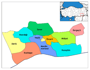
Mardin province is divided into 10 districts (capital district in 'bold):
- Mardin (Central district, after 2014 it will be named Artuklu)
- Dargeçit
- Derik
- Kızıltepe
- Mazıdağı
- Midyat
- Nusaybin
- Ömerli
- Savur
- Yeşilli
Gallery
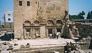
- Christian monuments in Mardin Province
-

Mor Yuhanun church
-

Mar Jacob Church in Nusaybin
-
Dayro d-Mor Hananyo monastery
- Islamic monuments in Mardin Province
-

Minaret of the grand mosque of Mardin (12th century) and the view of the Mesopotamian plains.
-
Kasimiye madrasa (14th century)
-

Zinciriye Madrasa (14th century)
-
View of Savur and the grand mosque in the center
-
Abdullatif mosque (14th century)
References
- ↑ Turkish Statistical Institute, MS Excel document – Population of province/district centers and towns/villages and population growth rate by provinces
- ↑ Watts, Nicole F. (2010). Activists in Office: Kurdish Politics and Protest in Turkey (Studies in Modernity and National Identity). Seattle: University of Washington Press. p. 167. ISBN 978-0-295-99050-7.
- ↑ Lipiński, Edward (2000). The Aramaeans: their ancient history, culture, religion. Peeters Publishers. p. 146. ISBN 978-90-429-0859-8.
- ↑ Payne Smith's A Compendious Syriac Dictionary, Dukhrana.com
- ↑ http://www.tatlidede.com.tr/en/mardin.php
External links
| Wikimedia Commons has media related to Mardin Province. |
- Mardin Weather Forecast Information
- Pictures of the capital of this province
- Articles about the Syriacs and photos of Midyat
- Mardin photos
- Tourism information is available in English at the Southeastern Anatolian Promotion Project site.
- Mardin Travel Guide
| |||||||||||||
Coordinates: 37°21′47″N 40°54′31″E / 37.36306°N 40.90861°E
