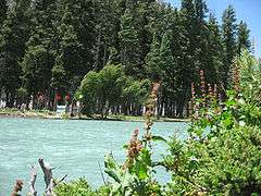
Mahodand Lake
Mahodand Lake (Pashto: د ماهو ډنډ - "Lake of Fishes") is a lake located in the upper Usho Valley at a distance of about 40 km from Kalam, Swat District, Khyber Pakhtunkhwa province of, northwestern Pakistan. It is a famous resort for holiday makers and always thronged from tourists. The lake is accessible by a four-wheel drive vehicle, and is a good place for fishing and boating.[1]
Geography
The Mahodand Lake lies at the foothills of Hindu kush mountains at an elevation of (9,603 ft), surrounded by the lush green meadows, snow clad mountains and dense forests. Similarly, the banks of Mahodand lake are covered by towering trees of pine species and sprawling pastures that serve as the camping site during the summer season for the visitors.
The Mahodand lake is fed by melting glaciers and springs of the Hindu kush mountain and gives rise to Ushu Khwar, the major left tributary of the Swat River.
Flora and fauna
During the winter, the Mahodand lake freezes and is covered by heavy snow. In the summers, the basin of the lake is surrounded by a sheet of alpine flowers like geum, blue poppy, potentilla and gentian are relatively common. Apart from it, the lake is encircled by diverse pinus species which serves as abode for wild birds. Similarly, the lake contains abounding trout fishes, which furnish ideal opportunity for angling, but catching is allowed only to the licensed anglers.[2]
Fishing & Camping
Huge number of visitors come to the lake side for camping,fishing, walking around and trekking to the nearby mountains. The waters of Mahodand lake are divided into a series of small and large streams, which once swarmed with brown and rainbow trout fishes introduced by the former ruler of Swat State. But due to over fishing by the locals for daily income and the illegal use of fishing methods like electrocution, dynamiting and use of large nets have reduced their number greatly.[3][4]

See also
| Wikimedia Commons has media related to Mahodand Lake. |
- Lake Saiful Muluk - Kaghan Valley
- Dudipatsar Lake - Kaghan Valley
- Saidgai Lake - Swat Valley
- Mahodand Lake - Kalam Valley
- Kundol Lake - Kalam Valley
- Daral Lake - Swat Valley
References
Coordinates: 35°42′50″N 72°39′01″E / 35.7138°N 72.6502°E