Mahina, French Polynesia
| Mahina | |
|---|---|
|
Matavai Bay during the second voyage of James Cook | |
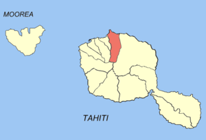
 Location of the commune (in red) within the Windward Islands | |
| Coordinates: 17°30′34″S 149°27′22″W / 17.5094°S 149.4561°WCoordinates: 17°30′34″S 149°27′22″W / 17.5094°S 149.4561°W | |
| Country | France |
| Overseas collectivity | French Polynesia |
| Government | |
| • Mayor | Émile Vernaudon |
| Area | 51.6 km2 (19.9 sq mi) |
| Population (August 2007 census)1 | 14,369 |
| • Density | 280/km2 (720/sq mi) |
| INSEE/Postal code | 98725 / 98709 |
| Elevation |
0–2,241 m (0–7,352 ft) (avg. 9 m or 30 ft) |
| 1 Population without double counting: residents of multiple communes (e.g., students and military personnel) only counted once. | |
Mahina is a commune in the suburbs of Papeete in French Polynesia, an overseas territory of France in the Pacific Ocean. Mahina is located on the island of Tahiti, in the administrative subdivision of the Windward Islands, themselves part of the Society Islands. Mahina is the 3rd largest city in French Polynesia with a population of 14,369. Mount Orohena is a nearby mountain.
History
The area of Mahina was first settled by early Polynesians from Asia. Canoes out of tree trunks were used to transport to Tahiti. The Polynesians had built houses out of grass on the beach and lived off of Fish and Bananas. They had hunted fish with spears and rocks. They had also picked up bananas from the land high above mean sea level. Captain James Cook had arrived on his expedition to chart Pacific Islands. He later sailed off to nearby Moorea and a few years later, he sailed to New Zealand and Australia. Charles Darwin had later come to Tahiti on his expedition. Don the Beachcomber had lived in Tahiti until his house was destroyed by a cyclone. Later on, the Faaa International Airport in Faaa was built in 1962. Many people from Mahina had used the airport. In 2007, Air Moorea crashed when it went to Moorea.
Transportation
Tahiti's west coast freeway ends in nearby Arue and small roads lead to the ending of the freeway. Other small roads lead in other directions. Most of the roads in Mahina are paved, while some are dirt and lead to the nearby mountains of Tahiti.
Geography

Mahina is on the northern coast of Tahiti about 9 meters above mean sea level. The commune of Arue is located to the west of Mahina. Mount Orohena is the tallest mountain in French Polynesia at 7,300 feet. Point Venus is a nearby lighthouse on the coast and people are able to view Moorea. Papenoo is a nearby comune that is home of the mouth of the Papenoo River.
Education
The University of French Polynesia is the only university in all of French Polynesia. Students from many other islands come to this university. The University of French Polynesia is a realitively small university with around 2,000 students. High schools are found throughout Tahiti. Some students in Mahina take classes in other countries such as the United States or New Zealand.
Economy
Many supermarkets are found throughout Mahina and mainly sell fruits such as bananas and apples. Banana trees grow in the mountains and delivery trucks bring the fruit down to Mahina's main supermarket. Mahina's supermarket has a larger variety of goods. The large Papeete supermarket in Papeete is nearby in the busy town center. Faaa has a big mall with clothing stores and Tahitian restaurants with a view of the Pacific Ocean. Mahina has a few industrial valleys that are home to factories. Some hardware stores such as Polybuild, Polymat, and Polywood are found in these valleys.
Safety
Mahina is close to the Faaa International Airport which has a few military planes. There are tests each day when they fly around Tahiti and other islands. In the airport terminal, Security guards check the passengers bag if they had brought along weapons of any kind. Police cars patrol the streets of Mahina to see if any drivers are speeding.
See also
| Wikimedia Commons has media related to Mahina. |
| ||||||||||
