Louisiana Highway 414
| ||||
|---|---|---|---|---|
 | ||||
| Route information | ||||
| Maintained by Louisiana DOTD | ||||
| Length: | 10.7 mi[1] (17.2 km) | |||
| Existed: | 1955 renumbering – present | |||
| Major junctions | ||||
| South end: |
| |||
|
| ||||
| North end: |
| |||
| Location | ||||
| Parishes: | Pointe Coupee | |||
| Highway system | ||||
| ||||
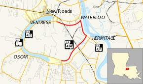
Louisiana Highway 414 (LA 414) is an east–west state highway located in Pointe Coupee Parish, Louisiana.
Route description
LA 414 begins at an intersection with Louisiana Highway 413 near Jarreau, Louisiana. The road goes east from its origin approximately 1.2 miles (1.9 km) before interesecting Louisiana Highway 983. From this intersection, it continues approximately 3.9 miles (6.3 km) in an east/northeast direction through the community of Chenal, Louisiana, before coming to another intersection with Louisiana Highway 415, near the 5.1 milepost. The road turns left (north) and shares the road bed of LA 415. At this point along the Mississippi River leve, the road is known locally as River Road. LA 414 continues north, sharing LA 415's roadbed, for approximately 2.2 miles (3.5 km). At this point, LA 415's milepost 20.8 and LA 414's milepost 7.3, the two roads split. LA 415 continues north, while LA 414 turn right (west). LA 414 continues west approximately 3.4 miles (5.5 km) before coming to its termination point at another intersection with LA 413 near milepost 10.7, in Ventress, Louisiana.
The speed limit is 45 miles per hour on LA 414, except for the portion of River Road (LA 415) shared by LA 414, where the speed limit is 55 mph (89 km/h).
Major junctions
The entire highway is in Pointe Coupee Parish.
| Location | mi[1] | km | Destinations | Notes | |
|---|---|---|---|---|---|
| Jarreau | 0.0 | 0.0 | |||
| Chenal | 1.2 | 1.9 | Western terminus of LA 983 | ||
| 4.9 | 7.9 | Southern end of LA 415 concurrency | |||
| Waterloo | 7.1 | 11.4 | Northern end of LA 415 concurrency | ||
| Ventress | 10.6 | 17.1 | |||
1.000 mi = 1.609 km; 1.000 km = 0.621 mi
| |||||
References
- 1 2 Google (February 15, 2015). "Louisiana Highway 414" (Map). Google Maps. Google. Retrieved February 15, 2015.
