Lose Hill
| Lose Hill | |
|---|---|
|
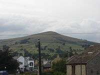
Lose Hill as seen from approach to Win Hill | |
| Highest point | |
| Elevation | 476 m (1,562 ft) |
| Prominence | 76 m (249 ft) |
| Geography | |
| Location | Peak District, England |
| OS grid | SK153854 |
| Topo map | OS Landranger 110 |
Lose Hill lies in the Derbyshire Peak District. It is the south-east corner of the parish of Edale and the end of the Great Ridge that runs from Rushup Edge to the west (over Mam Tor, Hollins Cross and Back Tor).
Local access activist G. H. B. Ward was given an area of Lose Hill by the Sheffield and District Federation of the Ramblers Association in 1945, which was named Ward's Piece; he subsequently presented this to the National Trust.[1]

Suggested explanations for the name of Lose Hill include that it derives from the Old English hlose, meaning pigsties, or that it may be a corruption of ‘loose’, as in ‘free land’. Another author (Murray) argues that Lose Hill should actually be called Laws Hill.[2]
References
- ↑ Edwards, Brian (Spring 2001). "A rambler made". Dore Village Society. Archived from the original on 15 October 2008.
- ↑ Henderson, Mark P (2011). Folk Tales of the Peak District. Amberley Publishing Limited. ISBN 1445601079.
| |||||||||||||||||
Coordinates: 53°21′55″N 1°46′18″W / 53.36525°N 1.77154°W
