Long Point, Ontario
| Long Point, Ontario | |
|---|---|
| Unincorporated hamlet in Norfolk County | |
|
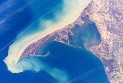
Long Point Peninsula with bright sediment plumes. (The top of the image points southwest, rather than north.) Source: NASA | |
 Long Point, Ontario Location of Long Point in Ontario | |
| Coordinates: 42°32′51″N 80°3′33″W / 42.54750°N 80.05917°WCoordinates: 42°32′51″N 80°3′33″W / 42.54750°N 80.05917°W | |
| Country |
|
| Province |
|
| Amalgamated | 2001 (Single-tier municipality) |
| Government | |
| • Mayor | Charlie Luke |
| • Governing Body | The Council of The Corporation of Norfolk County |
| • MPs | Diane Finley (Con) |
| • MPPs | Toby Barrett (PC) |
| Elevation | 210 m (690 ft) |
| Time zone | EST (UTC-5) |
| • Summer (DST) | EDT (UTC-4) |
| Postal code span | 1M0 |
| Area code(s) | 519 and 226 |
| Website |
www |
Long Point is a sand spit and medium-sized hamlet on the north shore of Lake Erie, part of Norfolk County in the province of Ontario, Canada.
It is about 40 kilometres long and is about a kilometre across at its widest point. Lake Erie lies to the south of Long Point, and Long Point Bay lies on the north side comprise. The bay is subdivided into the Inner Bay and Outer Bay by a line that runs between Turkey Point to the north and Pottohawk Point to the south. Some of the towns along the bay's north shore include Port Rowan, Turkey Point and Port Dover. Long Point is north of and across the lake from Erie, Pennsylvania.
Summary
The year-round population is about 450 people, but the population increases to about 5,000 in summer months when cottagers and campers visit.[1] Long Point is popular destination for boating, swimming, fishing, waterfowl-hunting and canoeing, and more than 100,000 visitors each year.[1] A large portion of Long Point is owned by the Long Point Company, a private organization that does not allow the public onto its property.[1] Because of this, most homes, cottages and business are within the first few kilometres of the causeway that carries the road between Long Point and the mainland.[1]

In the 19th century, a powerful storm cut an opening through the middle of Long Point. A lighthouse was built alongside the channel, which was the first of several on the point. The opening became known as "The Old Cut". The cut has since closed along the lakeshore, but boaters continue to use the northern portion to access the bay, homes and cottages.
During the mid-19th century some of local residents saw an opportunity to make easy money by "blackbirding". Blackbirders erected fake lighthouses during times of low visibility. Ships trying to enter the old cut would run aground. When the crew abandoned ship the blackbirders would loot the ship of cargo and other valuables. With law enforcement based in London, Ontario, these blackbirders would store their loot on the many hiding spots that Long Point offered.
Abigail Becker was a woman in the 19th century who waded into stormy waters to save the crew of a boat that had run aground. Long Point has caused many shipwrecks, with many of wrecks are right off the tip of point. More than 400 ships have sunk in an area called "The Lake Erie Quadrangle".
The region is an important location for bird migration in spring and autumn, including half of the eastern North American tundra swan population. The region is a major staging area for many breeds of waterfowl.
"Long Point itself is one of the most important wetland complexes for migrating waterfowl in southern Canada, and is reported to receive the highest waterfowl use (based on numbers of waterfowl days during spring and fall migration) of any area on the Great Lakes (approximately 4 million days per year). Up to 30,000 Tundra Swans pass through the area in spring, and up to 8% of the world's Canvasbacks congregate in the area on any one day during spring and fall," according to a report by the Long Point World Biosphere Reserve.
In 1960, the Long Point Bird Observatory was established to monitor migrant birds on the point. It is North America's oldest bird observatory. As a result of a growing national focus towards saving the birds, the organization was renamed Bird Studies Canada in 1998. Its national headquarters overlooks Long Point Inner Bay on the western limits of Port Rowan.
Long Point is an outstanding example of sand dune and sand-spit formation in the Great Lakes region. In 1982, Long Point National Wildlife Area was recognized as a wetland of international significance under the Ramsar Convention. It was designated as a World Biosphere Reserve by UNESCO in 1986. The Ontario Ministry of Natural Resources classifies Long Point as a Macrosite, an area that contains numerous ecological or geological significant zones,[2] such as Areas of Natural and Scientific Interest.
Long Point is the location of an Ontario provincial park, Long Point Provincial Park, a popular destination for day visitors and campers. North of the peninsula lie four islands classified as Lake Erie Islands:[3] Ryerson's, Second, Snow, and "Millionaire's Island", which is a collection of cabins located southwest of Ryerson's Island.[4]
Climate
According to the Atlas of Canada, Long point has a cool summer humid continental climate with no dry season (Köppen climate classification Dfb).[1] The climate of Long Point is influenced by Lake Erie, causing spring and summer temperatures to be cooler, and autumn and winter temperatures to be warmer than the adjacent mainland.[5] Winters are relatively cool, with a mean temperature of 1 °C (33.8 °F) while summers are warm, averaging 22 °C (71.6 °F).[1][5] Long Point averages 860 mm (34 in) of precipitation per year.[5] It is estimated that Long Point averages 2,000 hours of bright sunshine per year or 45% of possible sunshine.[1]
Gallery
- Views of Long Point, Ontario
-

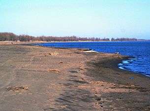
The marshes of Long Point, as seen from the Provincial Park.
-

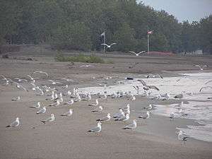
A flock of gulls on the beach.
-
View of a channel through the marsh in Long Point Bay.
-

Map of the Lake Erie Islands located near Long Point.
See also
Footnotes
- 1 2 3 4 5 6 7 "Three Wildlife Culverts (Ecopassages) on the Long Point Causeway between Lakeshore Rd and Erie Blvd, Long Point, Norfolk County Environmental Assessment Report" (PDF). The Corporation of Norfolk County. Retrieved 8 November 2015.
- ↑ "Natural Areas Report: LONG POINT BIOSPHERE RESERVE". Government of Ontario Ministry of Natural Resources. Retrieved 2007-07-30.
- ↑ How Many Islands Are There in Lake Erie?
- ↑ Gallant, Paul (30 October 2008). "Little-known Long Point". theStar.com. Retrieved 17 March 2014.
- 1 2 3 "Canada 2: Long Point National Wildlife Area, Ontario: Information Sheet on Ramsar Wetlands" (PDF). Retrieved 8 November 2015.
References
- Lore and Legends of Long Point, Harry B. Barrett, Burns and MacEachearn 1977, ISBN 0968608019
- Long Point: Last Port of Call, David Stone, Boston Mills Press, 1988, ISBN 0-919783-59-7
- Waters Of Repose, Dave Stone and David Frew, Erie County Historical Society 1993, ISBN 1-883658-19-5
External links
- Long Point Provincial Park
- Long Point Provincial Park Campgrounds
- The Long Point Bird Observatory
- Hunting and fishing website This site is mostly a pay per click site.
- Long Point's Outdoor Store
| ||||||||||||||||||||||||||||
| ||||||||||||||||||||||||||||||||||||||


