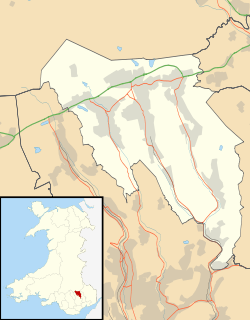
Llanhilleth
| Llanhilleth | |
| Welsh: Llanhiledd | |
 Llanhilleth |
|
| Population | 4,797 (2011)[1] |
|---|---|
| OS grid reference | SO2100 |
| Principal area | Blaenau Gwent |
| Country | Wales |
| Sovereign state | United Kingdom |
| Postcode district | NP13 |
| Dialling code | 01495 |
| Police | Gwent |
| Fire | South Wales |
| Ambulance | Welsh |
| EU Parliament | Wales |
| UK Parliament | Blaenau Gwent |
|
|
Coordinates: 51°41′50″N 3°08′09″W / 51.69729°N 3.135953°W
Llanhilleth (from Welsh Llanheledd, meaning "Church of Saint Heledd, the /i/ replacing the original /e/ due to the regional dialect of the area (Gwenhwyseg) changing the /e/ sound to /i/") is a village and an electoral ward on the A467 road between Ebbw Vale and Crumlin in Blaenau Gwent, Wales.
Two large mounds in the field behind the Carpenter’s Arms are the remains of the medieval Llanhilleth castle which originally had two large, stone-built towers.
Part of the Monmouthshire Canal ran through the parish; the Ebbw River forms the western boundary of the parish.
Nearby are the villages of Aberbeeg and St Illtyd, the latter of which contains the parish church.
See also
- Llanhilleth railway station, reopened in 2008
External links
- Llanhilleth Miners Institute
- Llanhilleth Rugby Club
- Llanhilleth Castle; further details on Castles of Wales
- Llanhilleth Colliery
- Two old photos of Llanhilleth
- Contemporary photos of Llanhilleth
References
- ↑ "Ward/Community population 2011". Retrieved 6 November 2015.
This article is issued from Wikipedia - version of the Sunday, January 24, 2016. The text is available under the Creative Commons Attribution/Share Alike but additional terms may apply for the media files.