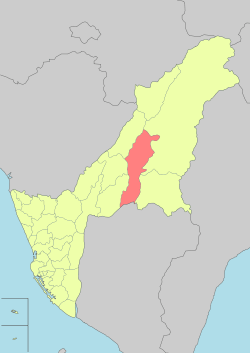
Liouguei District
Coordinates: 22°59′49″N 120°38′54″E / 22.996955°N 120.648315°E
| Liouguei 六龜區 | |
|---|---|
| District | |
| Liugui District [1] | |
 | |
 Liouguei District in Kaohsiung City | |
| Country | Taiwan |
| Region | Southern Taipei |
| Population (January 2016) | |
| • Total | 13,435 |
| Website | Official Website (Chinese) |
Liouguei District (Chinese: 六龜區; Hanyu Pinyin: Liùguī Qū; Tongyong Pinyin: Liòuguei Cyu; Wade–Giles: Liu4-kuei1 Ch'ü1) is a rural district of Kaohsiung City, Taiwan. It is the third largest district in Kaohsiung City after Tauyuan District and Namasia District.
History
Japanese Era
In 1902, in the early Japanese era, the area was called "La-ku-li Village" (六龜里庄). In 1910, it was modified to Rokkiri Subprefecture (六龜里支廳), Akugu Prefecture (阿緱廳). In 1920, it was under Rokuki Village (六龜庄), Heitō District (屏東郡), Takao Prefecture. In 1932, Rokuki Village (六亀庄) was annexed into Kizan District (旗山郡) under Takao Prefecture.
Administrative divisions
Liugui District consists of 12 villages.
Tourist attractions
- 18 Arhats Mountain
- Sinwei Forest Ecological Park
See also
| Wikimedia Commons has media related to Liouguei District, Kaohsiung. |
References
- ↑ "Glossary of Names for Admin Divisions" (PDF). placesearch.moi.gov.tw. Ministry of Interior of the ROC. Retrieved 12 June 2015.
External links
| ||||||||||||||||||||||||||||||||||
| ||||||||||||||||||||||||||||||||||||||||||||||
- ↑ "Glossary of Names for Admin Divisions" (PDF). placesearch.moi.gov.tw. Ministry of Interior of the ROC. Retrieved 12 June 2015.
This article is issued from Wikipedia - version of the Saturday, February 13, 2016. The text is available under the Creative Commons Attribution/Share Alike but additional terms may apply for the media files.
.svg.png)