List of earthquakes in Illinois

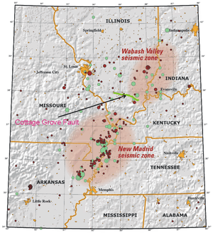
Map of seismic zones and faults in Illinois
The following is a list of earthquakes in Illinois.
- This list is incomplete; you can help by expanding it.
Earthquakes
See also
- 1811–12 New Madrid earthquakes
- New Madrid Seismic Zone
- Sandwich Fault Zone
- Wabash Valley Seismic Zone
Notes
- ↑ Stover & Coffman 1993, p. 224
- ↑ Stover & Coffman 1993, pp. 224–225
- ↑ "Historic Earthquakes - Aurora, Illinois 1909". Earthquake Hazards Program. United States Geological Survey. 26 October 2009. Retrieved 16 March 2010.
- ↑ Stover & Coffman 1993, pp. 224–225
- ↑ Huysken, K. T.; Fujita, K. (2013), "A Reevaluation of the Intensities of the Northern Illinois Earthquake of 1909", Bulletin of the Seismological Society of America (Seismological Society of America) 103: 2810–2823, doi:10.1785/0120130003
- ↑ Stover & Coffman 1993, pp. 224, 226, 227
- ↑ Stover & Coffman 1993, pp. 224, 228
- ↑ "Historic Earthquakes - Southern Illinois 1968". Earthquake Hazards Program. United States Geological Survey. 21 October 2009. Retrieved 17 March 2010.
- ↑ Stauder, William; Nuttli, Otto W. (June 1970). "Seismic studies: South central Illinois earthquake of November 9, 1968". Bulletin of the Seismological Association of America 60 (3): 973–981. Retrieved 17 March 2010.
- ↑ USGS 2014
- ↑ Heigold, Paul C. (December 1972). "Full text of "Notes on the earthquake of September 15, 1972, in northern Illinois". Illinois State Geological Society. Retrieved 10 June 2015.
- ↑ Stover & Coffman 1993, pp. 224, 228, 229
- ↑ "M4.9 - Illinois". USGS. Retrieved 8 June 2015.
- ↑ Howlett, Debbie (28 June 2004). "Earthquakes jolt Midwest, Alaska". USA Today. Retrieved 3 March 2010.
- ↑ "Magnitude 4.2 - ILLINOIS Earthquake Details". United States Geological Survey. 1 February 2010. Retrieved 16 February 2010.
- ↑ "M4.2 – Illinois Responses". U.S. Geological Survey. 27 October 2009. Retrieved 3 March 2010.
- ↑ Kim, Won-Young. "June 28, 2004, Ottawa, Illinois Earthquake". Lamont–Doherty Earth Observatory of Columbia University. Retrieved 3 March 2010.
- ↑ "Magnitude 5.4 - ILLINOIS". USGS. 28 January 2015. Retrieved 8 June 2015.
- ↑ Yang, H.; Zhu, L.; Chu, R. (2009), "Fault-Plane Determination of the 18 April 2008 Mount Carmel, Illinois, Earthquake by Detecting and Relocating Aftershocks" (PDF), Bulletin of the Seismological Society of America (Seismological Society of America) 99 (6): 3413–3420, doi:10.1785/0120090038
- ↑ "Magnitude 3.8 - ILLINOIS". USGS. 28 January 2015. Retrieved 8 June 2015.
- ↑ "M3.2 - 1km NW of Summit, Illinois". USGS. 4 November 2013. Retrieved 8 June 2015.
References
- "Illinois Earthquake Information". USGS. 18 April 2014. Retrieved 8 June 2015.
- Stover, Carl W.; Coffman, Jerry L. (1993). "Illinois". Seismicity of the United States, 1568-1989 (revised). U.S. Geological Survey Professional Paper 1527 (Washington, D.C.: United States Government Printing Office). pp. 223–230.
External links
-
 Media related to Earthquakes in Illinois at Wikimedia Commons
This article is issued from Wikipedia - version of the Saturday, February 06, 2016. The text is available under the Creative Commons Attribution/Share Alike but additional terms may apply for the media files.