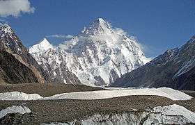
K2, the 2nd highest in the world
Pakistan is home to 108 peaks above 7,000 metres. and probably as many peaks above 6,000 m. There is no count of the peaks above 5,000 and 4,000 m. Five of the 14 highest independent peaks in the world (the eight-thousanders) are in Pakistan (four of which lie in the surroundings of Concordia; the confluence of Baltoro Glacier and Godwin Austen Glacier). Most of the highest peaks in Pakistan lie in the Karakoram mountain range (which lies almost entirely in the Gilgit–Baltistan region of Pakistan, and is considered to be a part of the greater Himalayan range) but some peaks above 7,000 m are included in the Himalayan and Hindu Kush ranges.
Considerations
The list is an incomplete list of mountains in Pakistan. There are many named and unnamed peaks in Pakistan that are currently not included in this list. The list also includes many peaks that are not usually classed as independent mountains, but instead are considered sub-peaks of other mountains, due to having low topographic prominence. Also, many of the elevations listed are approximate, due to imprecise and inconsistent surveys. The ranks in the peaks above 7,000 metres (23,000 ft) are derived from the list of highest mountains.
The dividing line between a mountain with multiple peaks and separate mountains is not always clear (see Highest unclimbed mountain). A popular and intuitive way to distinguish mountains from subsidiary peaks is by their height above the highest saddle connecting it to a higher summit, a measure called topographic prominence or re-ascent (the higher summit is called the "parent peak"). A common definition of a mountain is a summit with 300 m prominence (1,000 ft; also 10 traditional rope lengths). Alternatively, a relative prominence (prominence or height) is used (usually 7–8%) to reflect that in higher mountain ranges everything is on a larger scale. The list of highest mountains ranks the highest 100 summits with at least 500 m prominence, approximating a 7% relative prominence. A drawback of a prominence-based list is that it may exclude well-known or spectacular mountains that happen to be connected via a high ridge to a taller summit. Many such peaks and mountains with less than sufficient prominence are included but not numbered in the list.
It is very unlikely that all the heights given are correct to the nearest meter; indeed, problems of definition of sea level can arise when a mountain is remote from the sea. Different sources often differ by many meters, and the heights given below may well differ from those elsewhere in Wikipedia. Many mountains in the Karakorum differ by over 100 metres on different maps. These discrepancies serve to emphasise the uncertainties in the listed heights.
Geographical distribution
Most of the highest mountains in Pakistan are located in the Karakoram range (the highest of which is K2, globally ranked 2nd, 8611m), some high mountains are in Himalaya (the highest of which is Nanga Parbat, globally ranked 9th, 8126 m) and Hindu Kush (the highest of which is Tirich Mir, globally ranked 33rd, 7708 m).
The locations of the highest mountains are shown on the composite satellite image of Karakoram and Hindu Kush below. The numbers refer to the global ranking in this "List of highest mountains". For clarity, lower peaks with labels overlapping higher peaks are left out of the main image.
Most of the high peaks in Pakistan lie specifically in Gilgit–Baltistan with the exception of a few 7,000+ m peaks in the high Hindu Kush (the peaks marked in the northwest most region of Pakistan).
The peak marked as number 9 is Nanga Parbat (8,125 m), which is the 2nd highest Himalayan peak in Pakistan. All other peaks above 8,000m are in the Baltoro Muztagh subrange of Karakoram.
8000+ meters
7000 to 8000 meters
6000 to 7000 meters
5000 to 6000 meters
4000 to 5000 meters
3000 to 4000 meters
| Name | Height (m) | Location |
| Highest peak, Looi Sar Naikan | 3,578 m | Sulaiman Mountains | Zarghoon Ghar, Quetta |
| Makra Peak | 3,586 m | Himalayas | Kaghan |
| Ganga Choti | 3,044 m | Pir Panjal | Bagh |
| Pir Kanthi | 3,321 m | Pir Panjal | Bagh |
| Highest peak, Loai Saar | 3,472 m | Sulaiman Mountains | Koh-i-Takatu, Quetta |
| Highest peak, Lwarrh Saar | 3,194 m | Sulaiman Mountains | Koh-i-Chiltan, Quetta |
| Highest peak, Salore Ghasha | 3,184 m | Sulaiman Mountains | Koh-i-Murdaar, Quetta |
| Takht-i-Sulaiman | 3,487 m | Sulaiman Mountains | East of Quetta |
| Sadozaitop | 3,449 m | Toba Kakar Range | |
See also
Notes
- ^ Stated in the Pakistan Trekking Guide, by Isobel and Ben Shaw (along with the list of highest peaks of Pakistan in Appendices).
- ^ These ranks are derived from the List of highest mountains. Many peaks and mountains with less than sufficient prominence are included but not numbered in the list (see #Considerations.
- ^ The elevation of Hachindar Chhish given here is disputed by both Austrian and Russian topographic mapping, which give it 6870 m and 6765 m respectively.
Sources
- "High Asia: An Illustrated History of the 7,000 Metre Peaks" by Jill Neate (Mountaineers Books 1990)
- Soviet military 1:100,000 topographic maps (most from 1980–1981)
- The "High Mountain Info" section of the "High Mountain Sports Magazine" (1990–2005) (now Climb Magazine)
External links


.png)