List of rivers of Maine
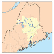
List of rivers in Maine (U.S. state).
The list is organized by tributary structure, from north to south along the coast.
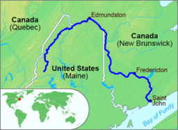
Saint John River

Saint John River
- Saint John River
Down East

St. Croix River watershed
- St. Croix River
- Little River (Passamaquoddy Bay)
- Pennamaquan River
- Hardscrabble River
- Dennys River
- Orange River
- Machias River
- Englishman River
- Chandler River
- Sandy River
- Indian River
- West River
- Pleasant River
- Harrington River
- Mill River
- Narraguagus River
- Skillings River
- Jordan River
- Union River
- East Branch Union River
- West Branch Union River
- Webb Brook
- Webb Pond
- Mill Brook
- Webb Pond
- Benjamin River
Penobscot Bay

Penobscot River watershed
- Bagaduce River
- Penobscot River
- Goose River (Belfast Bay)
- Passagassawakeag River
- Little River
- Ducktrap River
- Megunticook River
- Goose River (Rockport Harbor)
Mid Coast
- Weskeag River
- Saint George River
- Meduncook River
- Medomak River
- Pemaquid River
- Johns River
- Damariscotta River
- Sheepscot River
- West Branch Sheepscot River
- Dyer River
- Marsh River
- Cross River
- Back River (Boothbay, Maine)
- Sasanoa River (connects to Kennebec River)
- Little Sheepscot River
- Little River (Georgetown, Maine)
Kennebec River

Kennebec River

Androscogin River watershed
- Kennebec River
- Moose River
- Roach River
- Moxie Stream
- Dead River (also called West Branch)
- Carrabassett River
- Sandy River
- Sebasticook River
- Little River
- Eastern River
- Abagadasset River
- Androscoggin River
- Sasanoa River (connects to Sheepscot River)
- Back River (Kennebec River) (connects to Sheepscot River)
Southern Maine
- Morse River
- Sprague River
- New Meadows River
- Little River
- Harraseeket River
- Royal River
- Presumpscot River
- Fore River
- Spurwink River
- Scarborough River

Saco River watershed
- Saco River
- Little River (Goosefare Bay)
- Batson River
- Kennebunk River
- Mousam River
- Little River (Drakes Island, Maine)
- Webhannet River
- Ogunquit River
- Josias River
- Cape Neddick River
- Little River (York, Maine)
- York River
- Piscataqua River
See also
References
- USGS Geographic Names Information Service
- Maine Streamflow Data from the USGS
- Maine Watershed Data From Environmental Protection Agency
| ||||||||||||||||||||||||||||||
This article is issued from Wikipedia - version of the Friday, February 12, 2016. The text is available under the Creative Commons Attribution/Share Alike but additional terms may apply for the media files.