Langdon Lake
For the lake in Minnesota, see Lake Langdon.
| Langdon Lake | |
|---|---|
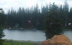
 Langdon Lake with part of Tollgate on the far bank. | |
| Location | Umatilla National Forest, Umatilla County, Oregon, US |
| Coordinates | 45°46′41″N 118°05′10″W / 45.77819°N 118.08606°WCoordinates: 45°46′41″N 118°05′10″W / 45.77819°N 118.08606°W[1] |
| Type | Reservoir |
| Primary inflows | Morning Creek |
| Primary outflows | Lookingglass Creek |
| Basin countries | United States |
| Surface elevation | 4,902 ft (1,494 m)[1] |
| Settlements | Tollgate |
Langdon Lake is reservoir located in the Umatilla National Forest of Northeastern Oregon, United States.[2] It is an impoundment of Morning Creek,[3] and the source of Lookingglass Creek, a tributary of the Grande Ronde River.
Surrounding the lake is the small community of Tollgate. The lake is privately owned but a campground is nearby.[2]
See also
References
- 1 2 "Langdon Lake". Geographic Names Information System. United States Geological Survey. May 22, 1986. Retrieved December 17, 2009.
- 1 2 "Walla Walla District Campgrounds". United States Forest Service. Retrieved December 16, 2009.
- ↑ "Tollgate Topo Map at Lat 45.7782°N Long -118.0861°W Zoom 15 S Size". Trails.com. Retrieved December 16, 2009.
This article is issued from Wikipedia - version of the Saturday, September 05, 2015. The text is available under the Creative Commons Attribution/Share Alike but additional terms may apply for the media files.