Vorpommern-Greifswald

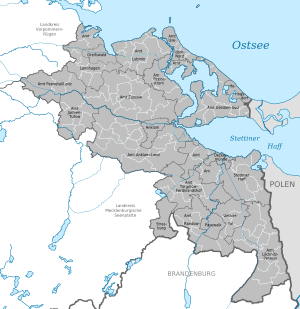
Map of municipalities and towns in Vorpommern-Greifswald
Vorpommern-Greifswald (Polish: Powiat Vorpommern-Greifswald) is a district in the east of Mecklenburg-Vorpommern, Germany. It is bounded by (from the west and clockwise) the districts of Mecklenburgische Seenplatte and Vorpommern-Rügen, the Baltic Sea, Poland (West Pomeranian Voivodeship) and the state of Brandenburg. The district seat is Greifswald.[2]
History
The district was established by merging the former districts of Ostvorpommern and Uecker-Randow with the subdivisions of Jarmen-Tutow and Peenetal/Loitz and the former district-free town Greifswald, as part of the local government reform of September 2011.[2] The name of the district was decided by referendum on 4 September 2011.[3] The project name for the district was Südvorpommern.
Towns and municipalities
References
- ↑ "Bevölkerungsstand der Kreise, Ämter und Gemeinden in Mecklenburg-Vorpommern 31.12.2013". Statistisches Amt Mecklenburg-Vorpommern (in German). 23 September 2014.
- 1 2 "Mecklenburg-Vorpommern government reform". Retrieved 5 September 2011.
- ↑ "Referendum results Mittleres Mecklenburg". Retrieved 5 September 2011.
External links
|
|---|
| | Urban districts | | |
|---|
| | Rural districts | |
|---|
|
Coordinates: 53°50′N 13°40′E / 53.833°N 13.667°E / 53.833; 13.667


