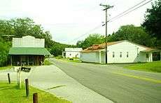
Lancaster, Tennessee
| Lancaster, Tennessee | |
|---|---|
| Unincorporated community | |
|
Intersection of Highway 141 and Maple Street in Lancaster | |
 Lancaster, Tennessee | |
| Coordinates: 36°07′40″N 85°52′08″W / 36.12778°N 85.86889°WCoordinates: 36°07′40″N 85°52′08″W / 36.12778°N 85.86889°W | |
| Country | United States |
| State | Tennessee |
| County | Smith |
| Elevation | 531 ft (162 m) |
| Population (2010)[1] | |
| • Total | 363 |
| Time zone | Central (CST) (UTC-6) |
| • Summer (DST) | CDT (UTC-5) |
| ZIP code | 38569 |
| Area code(s) | 615 |
| GNIS feature ID | 1290568[2] |
Lancaster is an unincorporated community in Smith County, Tennessee, United States, located 5.3 miles (8.5 km) southeast of Gordonsville. Lancaster had a post office with ZIP code 38569, which closed on March 4, 2011, due to the United States Postal Service closing smaller post offices around the country.[3][4][5]
As of 2010, the population of Lancaster's zip code tabulation area was 363.[1] The community is situated along State Highway 141 between Gordonsville and Center Hill Lake, and is drained by Smith Fork, a tributary of the Caney Fork. The community is named for John Lancaster, Jr., an early settler who arrived in the area in the late 18th century (his family still owns a farm in the area, which has been designated a Tennessee Century Farm).[6]
See also
- Temperance Hall, Tennessee - a community of similar size located just to the southwest in DeKalb County
References
- 1 2 United States Census Bureau, Statistics for 38569 Zip Code Tabulation Area, American FactFinder. Retrieved: 22 September 2013.
- ↑ "Lancaster". Geographic Names Information System. United States Geological Survey.
- ↑ Post Offices Closed in 2011. Save the Post Office. Retrieved: 22 September 2013.
- ↑ United States Postal Service (2012). "USPS - Look Up a ZIP Code". Retrieved 2012-02-15.
- ↑ "Postmaster Finder - Post Offices by ZIP Code". United States Postal Service. Retrieved July 20, 2012.
- ↑ Lancaster Farm, Tennessee Century Farms. Retrieved: 22 September 2013.
| |||||||||||||||||
