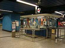
Lam Tin Station
Lam Tin 藍田 | |||||||||||||||
|---|---|---|---|---|---|---|---|---|---|---|---|---|---|---|---|
| MTR rapid transit station | |||||||||||||||
|
Platform 1 | |||||||||||||||
| Chinese name | |||||||||||||||
| Traditional Chinese | 藍田 | ||||||||||||||
| Simplified Chinese | 蓝田 | ||||||||||||||
| Literal meaning | Blue field | ||||||||||||||
| |||||||||||||||
| General information | |||||||||||||||
| Location |
Lei Yue Mun Road, Lam Tin Kwun Tong District, Hong Kong | ||||||||||||||
| Coordinates | 22°18′24″N 114°13′59″E / 22.3068°N 114.2330°ECoordinates: 22°18′24″N 114°13′59″E / 22.3068°N 114.2330°E | ||||||||||||||
| Operated by | MTR Corporation | ||||||||||||||
| Line(s) | |||||||||||||||
| Platforms | 2 (island platform) | ||||||||||||||
| Connections | Bus, public light bus | ||||||||||||||
| Construction | |||||||||||||||
| Structure type | At-grade | ||||||||||||||
| Platform levels | 1 | ||||||||||||||
| Disabled access | Yes | ||||||||||||||
| Other information | |||||||||||||||
| Station code | LAT | ||||||||||||||
| History | |||||||||||||||
| Opened |
| ||||||||||||||
| Services | |||||||||||||||
| |||||||||||||||
| Location | |||||||||||||||
 Lam Tin Location within the MTR system | |||||||||||||||

Lam Tin is a station on the Hong Kong MTR Kwun Tong Line built as a part of the extension to Quarry Bay. The station is linked to the hillside community of the Lam Tin area by a series of escalators.
History
In the 1980s, the Eastern Harbour Crossing (EHC or EHT) was planned by the colonial government. Following the successful performance of the MTR since 1978, the government decided to extend the Kwun Tong Line through a new tunnel to Quarry Bay.
It was later decided that before the entrance to the tunnel, trains would stop at a station in the Lam Tin Valley, where it goes into the Sai Tso Wan Hill and then underground to the entrance of the tunnel.
The station was opened in October 1989. As part of his official visit with then Princess of Wales to Hong Kong, the Prince of Wales officiated the opening of the station, in which a commemorative plaque remains on display to this day.
After the opening of the EHC, Lam Tin, with the MTR station and bus terminals, became a crucial transport interchange in east Kowloon. The station serves passengers between Tseung Kwan O and other parts of Kowloon as well as between Hong Kong and Kowloon.
Platform screen doors have been in use since late August 2005.
Timetable
| Line | Destination | First train | Last train | |
|---|---|---|---|---|
| Kwun Tong Line | Tiu Keng Leng | 06:05 | 01:05 | |
| Yau Ma Tei | 06:12 | 00:28 | ||
| Choi Hung | 01:11 | |||
| Kwun Tong | 01:20 | |||
| Source: MTR[1] | ||||
Station layout
Platforms 1 and 2 share the same island platform. Like Lai King Station, Lam Tin Station is built on an elevated platform, in which half of the platform is immersed into the Lam Tin Hill[2][3] and so the station is sealed like other underground stations (but it is mixed as an elevated, ground level, and underground station).
The concourse is the first floor down the escalators from the hillside exits. It is divided into two parts: the paid area and the non-paid area. The paid area has escalators down to the platforms and has a postbox, while the non-paid area links the exits and houses a Hang Seng Bank branch.
Between the paid and non-paid areas there are the entrance gates and a customer service centre which serves both areas.
| - | Subway (Kai Tin Road) |
Subway to Kai Tin Road and Lam Tin North |
| C Concourse (Ground) |
Concourse | Exits, footbridges |
| Customer service, MTRshops | ||
| Hang Seng Bank, vending machines, automatic teller machines | ||
| Footbridge | Footbridge to Sceneway Garden | |
| Transport interchange, Subway to Kai Tin Road | ||
| P Platforms |
Platform 1 | Kwun Tong Line towards Tiu Keng Leng (Yau Tong) → (No regular service: Quarry Bay) |
| Platform 2 | ← Kwun Tong Line towards Yau Ma Tei (Kwun Tong) | |
Entrances/exits
- A: Kai Tin Estate
- B: Public Transport Interchange, Sceneway Plaza
- C: Lei Yue Mun Road

- D1: Sin Fat Road
- D2: Sceneway Garden[5]
Transport connections
Following the MTR station's opening in 1989, the area around Lam Tin Station has been developed into a major transportation interchange in Hong Kong. The shopping centre and Sceneway Plaza above the transportation interchange adjacent to the station were built on a site that used to be occupied by a hillside squatter village.
The original Lam Tin community has also seen several rebuilding projects since the station had been built. The interchange has brought in new residential and commercial demand in the community. The bus termini, the Lei Yue Mun Interchange, and other public transportation facilities had transformed the Lam Tin area into an important transportation hub as well as a commercial and residential centre.
These routes terminate at the Lam Tin MTR Bus Terminus:
- A22 to Hong Kong Airport
- 42C to Cheung Hang Estate, Tsing Yi
- 61R to City One Shatin
- 89D to Wu Kai Sha Station
- 93M to Po Lam
- 216M to Yau Tong (circular)
- 258D to Po Tin Estate, Tuen Mun
- 277E, 277P to Tin Ping Estate, Sheung Shui
- 277X to Luen Wo Hui, Fanling
References
- ↑ "Lam Tin Station timetable" (PDF). MTR Corporation. Retrieved 25 July 2014.
- ↑ Hong Kong Guide 2004, HKSAR Government, February 2004.
- ↑ Hong Kong Guide 2005, HKSAR Government, April 2005.
- ↑ "Lam Tin Station layout" (PDF). MTR Corporation. Retrieved 31 July 2014.
- ↑ "Lam Tin Station street map" (PDF). MTR Corporation. Retrieved 31 July 2014.
| Wikimedia Commons has media related to Lam Tin Station. |
| ||||||||||||||||||||||||||||||||||||||||||||||||||||||||||||||||||||||||||||||||||||||||||||||||||||||||||||||