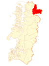
Lago Verde, Chile
| Lago Verde | ||||
|---|---|---|---|---|
| Commune | ||||
| ||||
| Coordinates (commune): 44°14′S 71°50′W / 44.233°S 71.833°WCoordinates: 44°14′S 71°50′W / 44.233°S 71.833°W | ||||
| Country | Chile | |||
| Region | Aysén | |||
| Province | Coihaique | |||
| Founded as | Villa La Tapera | |||
| Founded | 1926 | |||
| Government[1][2][3] | ||||
| • Type | Municipality | |||
| • Alcalde | Nelson Opazo López (UDI) | |||
| Area[4] | ||||
| • Total | 5,622.3 km2 (2,170.8 sq mi) | |||
| Elevation | 422 m (1,385 ft) | |||
| Population (2012 Census)[5] | ||||
| • Total | 869 | |||
| • Density | 0.15/km2 (0.40/sq mi) | |||
| • Urban | 0 | |||
| • Rural | 869 | |||
| Time zone | CLT [6] (UTC-4) | |||
| • Summer (DST) | CLST [7] (UTC-3) | |||
| Area code(s) | 56 + 67 | |||
| Website | Municipality of Lago Verde | |||
Lago Verde is a Chilean commune located at the headwaters of the Cisnes River in Coyhaique Province, Aisén Region. The commune is administered by the municipality of Lago Verde, the principal settlement.
History
At the time of European arrival, the indigenous people in the area were the Tehuelche, who were nomadic hunter gatherers,[8] however, the area has been occupied since at least 2,800 BP, and likely back as far as the end of the last ice age (11,400 BP).[9][10] Some Europeans settled in the area in the early twentieth century, beginning in 1914 there were settlers in the upper reaches of the Cisnes River. The grant for the estancia "Sociedad Ganadera Cisnes" of over 1,000 square kilometres (386 sq mi) was made in the early 1920s. It encompassed almost all of what is now the La Tapera district. Nonetheless, the area was not formally organized until the establishment of a settlement, Villa La Tapera, on 26 December 1926.[8]
In 1936 land for the establishment of the town of Lago Verde was set aside. In 1950, a young Frenchman, Edward Simon. purchased several hectares in the town and established a hotel, the "Cacique Blanco", with the ranching and farming activities to support it. In 1966 Villa La Tapera achieved town status. In 1979 the commune of Lago Verde was created. In 1981 Lago Verde became a municipality. And in 1982 Villa Amengual was founded.[8]
In 1992 the road to La Junta was completed with a bridge over the Rosselot River. This inceased communications within the region.[8]
Demographics
According to the 2012 census of the National Statistics Institute, Lago Verde has 869 inhabitants, with an area of 5,622.3 km2 (2,171 sq mi) which makes the commune an entirely rural area.[5] The population of the commune has been declining; it was 1,062 in the 2002 census, and 1,168 in the 1992 census.[4]
Administration
As a commune, Lago Verde is a third-level administrative division of Chile administered by a municipal council, headed by an alcalde who is directly elected every four years.[2][3] The 2012-2016 alcalde is Nelson Opazo López.[11] The presious governor was Gaspar Aldea Cadagán.[4]
Within the electoral divisions of Chile, Lago Verde is represented in the Chamber of Deputies by René Alinco (PDC) and David Sandoval (UDI) as part of the 59th electoral district, which includes the entire Aisén Region. The commune is represented in the Senate by Antonio Horvath Kiss (RN) and Patricio Walker Prieto (PDC) as part of the 18th senatorial constituency (Aisén Region).
Notes and references
- ↑ "Asociación Chilena de Municipalidades" (PDF) (in Spanish). Municipality of Lago Verde. Archived (PDF) from the original on 21 August 2015.
- 1 2 "Consejo Municipal" (in Spanish). Municipality of Lago Verde. Archived from the original on 21 August 2015.
- 1 2 "Administración y Finanzas" (in Spanish). Municipality of Lago Verde. Archived from the original on 21 August 2015.
- 1 2 3 División de Planificación y Desarrollo Regional. "Carpeta Comunal: Comuna de Lago Verde". Proyecto de actualización de carpetas comunales (in Spanish). Gobierno Regional de Aysén. Archived from the original on 21 August 2015.
- 1 2 Codigo 11102, Lago Verde Comisión Externa Revisora del Censo 2012 (August 2013). "Anexo 1. Población Reportada a Nivel Comunal" (PDF). Al Informe Final: Anexos (in Spanish). National Statistics Institute (INE). p. 49. Archived from the original (PDF) on 3 December 2014.
- ↑ "Chile Time". WorldTimeZones.org. Retrieved 26 September 2010.
- ↑ "Chile Summer Time". WorldTimeZones.org. Retrieved 26 September 2010.
- 1 2 3 4 "Historia de Lago Verde". Municipalidad de Lago Verde. Archived from the original on 15 August 2015.
- ↑ Méndez M., César A. and Reyes B., Omar R. (2008). "Late Holocene human occupation of the Patagonian forests: A case study in the Cisnes river basin". Antiquity 82 (317): 560–570.
- ↑ Scheinsohn, Vivian; Szumik, Claudia; Leonardt, Sabrina and Rizzo, Florencia (2015). "The “Hidden” Code: Coding and Classifying in Rock Art: The Case of Northwestern Patagonia" (PDF). Journal of Archaeological Method and Theory. doi:10.1007/s10816-015-9249-8.
- ↑ "Presentación del Alcalde" (in Spanish). Municipality of Lago Verde. Archived from the original on 21 August 2015.
External links
- (Spanish) Municipality of Lago Verde
| ||||||||||||||||||||


