Lafayette Place Historic District
|
Lafayette Place Historic District | |
 | |
|
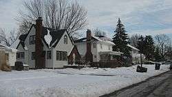
Lafayette Place Historic District, January 2014 | |
 | |
| Location | Roughly bounded by S. Calhoun and Lafayette Sts., and McKinnie and Pettit Aves., Fort Wayne, Indiana |
|---|---|
| Coordinates | 41°02′40″N 85°08′00″W / 41.04444°N 85.13333°WCoordinates: 41°02′40″N 85°08′00″W / 41.04444°N 85.13333°W |
| Area | 86 acres (35 ha) |
| Built | c. 1915-1963 |
| Architect | Shurcliff, Arthur; Ninde, Lee J.; et al. |
| Architectural style | Tudor Revival, Colonial Revival, Bungalow / craftsman et al. |
| MPS | Historic Residential Suburbs in the United States, 1820-1960 MPD |
| NRHP Reference # | 12001147[1] |
| Added to NRHP | January 9, 2013 |
Lafayette Place Historic District is a national historic district located at Fort Wayne, Indiana. The district encompasses 582 contributing buildings, 1 contributing site, 1 contributing structure, and 1 contributing object in a predominantly residential section of Fort Wayne. The area was developed from about 1915 to 1963, and includes notable examples of Colonial Revival, Tudor Revival, and Bungalow / American Craftsman style residential architecture. The neighborhood was platted and designed by noted landscape architect Arthur Asahel Shurcliff.[2]:3–7
It was listed on the National Register of Historic Places in 2013.[1]
References
- 1 2 "National Register of Historic Places Listings". Weekly List of Actions Taken on Properties: 1/07/13 through 1/11/13. National Park Service. 2013-11-18.
- ↑ "Indiana State Historic Architectural and Archaeological Research Database (SHAARD)" (Searchable database). Department of Natural Resources, Division of Historic Preservation and Archaeology. Retrieved 2015-07-01. Note: This includes Margaret Caviston, Michael Galbraith, and Angie Quinn (March 2012). "National Register of Historic Places Inventory Nomination Form: Lafayette Place Historic District" (PDF). Retrieved 2015-07-01. and Accompanying photographs and map.
| ||||||
This article is issued from Wikipedia - version of the Friday, October 30, 2015. The text is available under the Creative Commons Attribution/Share Alike but additional terms may apply for the media files.

