Kysuca
| Kysuca | |
|---|---|
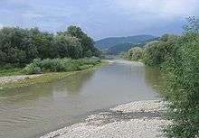
 River Kysuca near Kysucké Nové Mesto after short summer storm | |
| Basin | |
| River system | Danube |
| Main source | Javorníky mountains, near Makov (Žilinský kraj , Slovakia) |
| Source elevation | 610 m (2,000 ft) |
| River mouth |
Váh in Žilina 49°14′07″N 18°43′50″E / 49.23528°N 18.73056°ECoordinates: 49°14′07″N 18°43′50″E / 49.23528°N 18.73056°E |
| Size | 1,038 km2 (401 sq mi) |
| Physiognomy | |
| Length | 66.3 km (41.2 mi) |
The Kysuca River (Hungarian: Kiszuca) is a 66.3 km long river in northern Slovakia and it's a right tributary to Váh. The river gives name to the informal Kysuce region.
Its source is near the village of Makov. At first, the river flows in northwestern direction, where it flows around Javorníky on the right and Kysucké Beskydy mountains on the left side, passing through the town of Turzovka until the town of Čadca, where it turns south, between Javorníky on the right and Kysucká vrchovina mountains on the left side, passing Horelica, Krásno nad Kysucou, Kysucké Nové Mesto until it pours to Váh in Žilina. In the valley of Kysuca south of Čadca, a railway and an international road (currently E75, in the future D3) passes through it.
.jpg)
Kysuca river in winter - Čadca
| Wikimedia Commons has media related to Kysuca. |
This article is issued from Wikipedia - version of the Thursday, February 11, 2016. The text is available under the Creative Commons Attribution/Share Alike but additional terms may apply for the media files.