Kuala Pilah
| Kuala Pilah 瓜拉庇劳 | ||
|---|---|---|
| Town | ||
| ||
 Kuala Pilah 瓜拉庇劳 Location of Tampin in Peninsular Malaysia | ||
| Coordinates: 2°44′19.6″N 102°14′57.5″E / 2.738778°N 102.249306°E | ||
| Country |
| |
| State |
| |
| Government | ||
| • Type | District Council (Majlis Daerah) | |
| Time zone | MST (UTC+8) | |
| Postcode | 72xxx | |
| Website | Kuala Pilah District Council | |


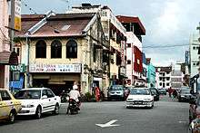
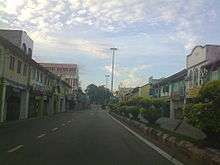
Kuala Pilah is a town, a district and a parliamentary constituency in Negeri Sembilan, Malaysia. Commonly called Pilah by the mainly Malay Minangkabau inhabitants, it is also the name of a district. It is an old valley town with many of the pre-war Chinese shop houses still fronting the main streets surrounded by traditional style Malay village houses built on stilts nestled among extensive rice fields. Among the local specialties are Minangkabau food, including masak lemak cili api and daging salai masak kicap.[1]
Kuala Pilah town itself is a main stopover for transport routes. It has a sizable Chinese community that has existed since the mining days during the early British rule. This community today engage in trading and providing essential services such as workshops, hairdressing and coffee shops.

On the main road is a Chinese-styled arch dedicated to Martin Lister, who was the first British Resident of Negeri Sembilan, commemorating his effort in ending the intermittent violent conflict between Chinese secret societies then rampant among the migrant Chinese populace. Lister was killed by his enemies in the nearby hills at Ulu Bendul. The old Kuala Pilah Rest house was a government built rest house during the British occupation. In the early years, rest houses were the only available hotels and where everyone from businessmen to travellers stayed. Today it still serves this purpose, albeit in a diminished capacity due to the availability of alternative accommodation.
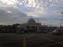
It is a small town. A police station situated nearby the Pejabat Tanah dan Daerah and next to it was TNB office and also a Kuala Pilah District Masjid close to each other. There's a new District Hospital named Hospital Daerah Tuanku Najihah, at the main road towards Seremban Town.
Weekends are busy usually those from Kuala Lumpur folks returning to their home town, visiting their parents, tending to family plots, where around the area is mostly Malays that migrated to Kuala Lumpur in search of better prospects and 'the bright lights'.
The town is quite empty at night as most of the shops close as early as 7.00 pm daily. But early mornings are busy as there were workers and residents staying nearby going to work at government offices such as hospitals, district offices, schools, an UiTM branch nearby.
There are not many food stalls around and are limited to the junction between Kuala Pilah and Bahau. The only theater was closed due to the introduction of video and internet cafes that sprouted during the 1990s and are still going strong today. There is a new Bus Station and Taxi Stand located in the middle of Kuala Pilah Town and services to Seremban, Kuala Lumpur, Tampin, Bahau and Gemas are available—also to the East Coast towns of Kuantan and Kuala Terengganu. People from Segamat and parts of Pahang use this route through Kuala Pilah to go to Kuala Lumpaur via Seremban.
One thing nice about Kuala Pilah is the people, who are friendly and aren't shy to greet one another and should you ask for directions they will surely show your safely on your way. There is a Muslim mosque beside a Chinese temple and a Sikh temple beside a large Hindu temple. This comes to show the unity of the people in Kuala Pilah.
Royal town
Kuala Pilah constituency is also home to Sri Menanti, the official residence of the Yang di-Pertuan Besar of Negeri Sembilan.
Transportation
Car
Kuala Pilah is perhaps being famous for being an important rest town for travellers using highway ![]() , which runs through downtown Kuala Pilah. This highway, beginning in Tampin near the Negeri Sembilan-Malacca border and ending in Karak in western Pahang, is the main route for motorists from Malacca and Negeri Sembilan heading to the east coast states of Pahang, Terengganu and Kelantan while bypassing Kuala Lumpur/the Klang Valley.
, which runs through downtown Kuala Pilah. This highway, beginning in Tampin near the Negeri Sembilan-Malacca border and ending in Karak in western Pahang, is the main route for motorists from Malacca and Negeri Sembilan heading to the east coast states of Pahang, Terengganu and Kelantan while bypassing Kuala Lumpur/the Klang Valley.
Meanwhile, Kuala Pilah is connected to the state capital, Seremban by highway ![]() .
.
Public transport
Currently state railway operator KTMB does not serve Kuala Pilah. The closest stations will be KB13 Seremban and Bahau.
There used to be a branch line connecting Kuala Pilah to KB19 Gemas; the branch line was dismantled during the Japanese occupation for construction of the Death Railway in Burma.
Politics
Currently Kuala Pilah is represented in the Dewan Rakyat of the Malaysian Parliament by Dato' Seri Hasan Malek of UMNO, part of the federal ruling coalition Barisan Nasional. Hasan Malek was previously the Minister of Domestic Trade, Co-operatives and Consumerism.[2]
In turn, Kuala Pilah provides 5 seats to the Negeri Sembilan State Legislative Assembly, namely:
- Juasseh;
- Seri Menanti, the royal town;
- Senaling;
- Pilah, which included downtown Kuala Pilah; and
- Johol.
All five state seats are also currently held by UMNO.[3]
Tourist attractions
- Ulu Bendul Recreation
Situated 16 km from Seremban on the way to Kuala Pilah / Sri Menanti, this recreation garden is surrounded by mountains an ideal spot to relax away from the bustling town. Lying near the foot of the 2500 ft Mount Angsi, fresh water from the streams flows into the man made lake. This recreational park was built in 1972 and is located at compartments 45 and 52 of the Angsi Forest Reserve (Hutan Simpan Angsi) in Negeri Sembilan. Located 200 m above sea level, the forest is categorised as the main attraction here with the summit reaching to 825 m above sea level. There are long-cabin for mountain climbers, tracks for hikers and jungle paths for the adventures.
See also
References
- ↑ http://www.utusan.com.my/berita/wilayah/luqman-dilantik-ocpd-kuala-pilah-1.130568
- ↑ "Ahli Parlimen". Portal Rasmi Parlimen Malaysia. Retrieved 24 January 2016.
- ↑ "Senarai ADUN Barisan Nasional". Barisan Nasional. Retrieved 24 January 2016.
| ||||||||||||||||||||||
Coordinates: 2°44′N 102°15′E / 2.733°N 102.250°E
