Kotagiri
| Kotagiri | |
|---|---|
| Town | |
|
Kotagiri village | |
| Nickname(s): KTG | |
 Kotagiri | |
| Coordinates: 11°26′N 76°53′E / 11.43°N 76.88°ECoordinates: 11°26′N 76°53′E / 11.43°N 76.88°E | |
| Country | India |
| State | Tamil Nadu |
| District | The Nilgiris |
| Elevation | 1,793 m (5,883 ft) |
| Population (2001) | |
| • Total | 29,184 |
| Languages | |
| • Official | Badaga, Tamil |
| Time zone | IST (UTC+5:30) |

Kotagiri is a panchayat town in The Nilgiris District in the Indian state of Tamil Nadu. Kotagiri is situated at an elevation of around 1793m above sea level and is one of the three popular hill stations located in the Nilgiris.
Geography
Kotagiri is located at 11°26′N 76°53′E / 11.43°N 76.88°E.[1] It has an average elevation of 1793 metres (5882 ft).
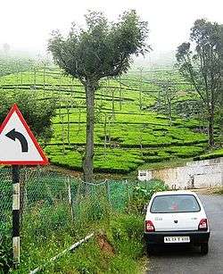
The region is famous for its evergreen vegetation. Tea, eucalyptus and wintergreen grow well in this area. The soil is also ideal for the cultivation of temperate fruits and vegetable with a lot of local farmers turning to brussels sprout, cabbages, carrots and mushroom cultivation among other crops.
Demographics
As of 2001 India census,[2] Kotagiri had a population of 29,184. Males constitute 49% of the population and females 51%. Kotagiri has an average literacy rate of 77%, higher than the national average of 59.5%: male literacy is 84%, and female literacy is 70%. In Kotagiri, 9% of the population is under 6 years of age. The Badagas people are native to the region and own most of the property around Kotagiri.
Places of interest

Kodanad View Point is accessible by road, 16 km (9.9 mi) from Kotagiri or about 30 minutes by vehicle. It provides a splendid view of the great Mysore Plateau to one side and the picturesque 50-acre (200,000 m2) farming cooperative called Thengumarahada, which looks like a green mosaic amidst the shrubland. Lazily meandering through this little village is the Moyar river.
The Kodanad View Point offers a panoramic view of the distant plateaux, tea estates, Thengumarahada village, Kil-Kotagiri region peaks, the Moyar river and more. Kodanad View Point is situated 18 km from Kotagiri.
The Rangaswamy Pillar rising to a height of some 400 feet (120 m) and has sheer narrow sides.
Educational institutions
- St. Jude's Public School & Junior College
- St. Marys Home Matriculation School
- NPA Centenary Polytechnic College:[3]
Transportation links
Kotagiri is linked by road to Mettupalayam. The road which continues to Ooty (27 km from Kotagiri to Ooty) is one of the Nilgiri Ghat Roads and is now one of the five main access routes for the district. Coonoor is 23 km from Kotagiri and connected by a road that branches off the Ooty road.
References
- ↑ Falling Rain Genomics, Inc - Kotagiri
- ↑ "Census of India 2001: Data from the 2001 Census, including cities, villages and towns (Provisional)". Census Commission of India. Archived from the original on 2004-06-16. Retrieved 2008-11-01.
- ↑ "NPA, Kotagiri". Retrieved 2011-01-12.
External links
| Wikimedia Commons has media related to Kotagiri. |
- http://www.hindu.com/2007/12/01/stories/2007120151680300.htm
- http://www.hindu.com/mp/2009/04/11/stories/2009041152070500.htm
