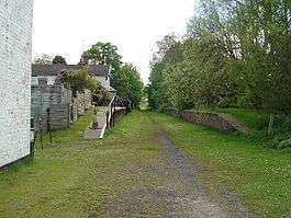
Kiplingcotes railway station
| Kiplingcotes | |
|---|---|
|
The old trackbed through Kiplingcotes station | |
| Location | |
| Place | Kiplingcotes |
| Area | East Riding of Yorkshire |
| Coordinates | 53°52′57″N 0°35′26″W / 53.8826°N 0.5905°WCoordinates: 53°52′57″N 0°35′26″W / 53.8826°N 0.5905°W |
| Grid reference | SE927438 |
| Operations | |
| Original company | York and North Midland Railway |
| Pre-grouping | North Eastern Railway |
| Post-grouping |
London and North Eastern Railway British Railways |
| Platforms | 2 |
| History | |
| 1865 | opened |
| 1965 | closed |
| Disused railway stations in the United Kingdom | |
|
Closed railway stations in Britain A B C D–F G H–J K–L M–O P–R S T–V W–Z | |
| UK Railways portal | |
Kiplingcotes railway station was a minor railway station on the disused York to Beverley Line, in the East Riding of Yorkshire, England. It opened on 1 May 1865 and served the nearby village of Kiplingcotes.
It was built originally for the personal use of local landowner and MP, Lord Hotham as an incentive for him to allow the railway to pass through his estates. The station closed on 27 November 1965. The station building, platforms and signal box still survive unaltered, as does the station master's house.
References
External links
- Station on navigable 1947 O.S. map
- "Station Name: Kipling Cotes". Disused Stations. Subterranea Britannica. 21 April 2011. Retrieved 11 December 2011.
| Preceding station | Disused railways | Following station | ||
|---|---|---|---|---|
| Market Weighton | Y&NMR York to Beverley Line |
Cherry Burton | ||
This article is issued from Wikipedia - version of the Monday, January 18, 2016. The text is available under the Creative Commons Attribution/Share Alike but additional terms may apply for the media files.
