Kimbolton, Cambridgeshire
| Kimbolton | |
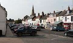 Kimbolton High Street |
|
 Kimbolton |
|
| Population | 1,477 (2011 Census) |
|---|---|
| OS grid reference | TL102681 |
| Civil parish | Kimbolton and Stonely |
| District | Huntingdonshire |
| Shire county | Cambridgeshire |
| Region | East |
| Country | England |
| Sovereign state | United Kingdom |
| Police | Cambridgeshire |
| Fire | Cambridgeshire |
| Ambulance | East of England |
| EU Parliament | East of England |
|
|
Coordinates: 52°18′N 0°23′W / 52.3°N 0.38°W
Kimbolton is a village and civil parish in Cambridgeshire, England.[1] Kimbolton lies approximately 9 miles (14 km) west of Huntingdon and 14 miles (23 km) north of Bedford. Kimbolton is situated within Huntingdonshire which is a non-metropolitan district of Cambridgeshire as well as being a historic county of England. The parish includes the hamlet of Stonely.
Katherine of Aragon, after her divorce from Henry VIII, died at Kimbolton Castle in 1536.
History
Kimbolton, and the lands of its soke, comprised the only estate of King Harold in Huntingdonshire. It is believed that Harold had a hunting lodge nearby. Kimbolton and its church, St Andrew's, appear in the Domesday book, compiled in 1086.
Many members of the Montagu family (Earls and Dukes of Manchester of Kimbolton Castle) are buried at St Andrew’s Church. Several Montagu monuments still exist in the South Chapel, while the Montagu vault (extended in 1853) is located beneath the North Chapel.[2]
The main road through Kimbolton bends through four tight right angles in quick succession. Originally, the road travelled directly through the outskirts of the village, nearer to the River Kym to the north.
The parish also includes the hamlet of Stonely, the site of a former Augustinian priory.[3]
Castle

The centre of the village is Kimbolton Castle which now forms the main building of Kimbolton School (an independent day and boarding school), but its predecessor on the same site was once home and prison to Katherine of Aragon after her divorce from Henry VIII. Katherine died at Kimbolton Castle in 1536 and was transported from there to Peterborough Cathedral to be buried.[4]
Government
As a civil parish, Kimbolton has a parish council. The parish council is elected by the residents of the parish who have registered on the electoral roll; the parish council is the lowest tier of government in England. A parish council is responsible for providing and maintaining a variety of local services including allotments and a cemetery; grass cutting and tree planting within public open spaces such as a village green or playing fields. The parish council reviews all planning applications that might affect the parish and makes recommendations to Huntingdonshire District Council, which is the local planning authority for the parish. The parish council also represents the views of the parish on issues such as local transport, policing and the environment. The parish council raises its own tax to pay for these services, known as the parish precept, which is collected as part of the Council Tax.
Kimbolton was in the historic and administrative county of Huntingdonshire until 1965. From 1965, the village was part of the new administrative county of Huntingdon and Peterborough. Then in 1974, following the Local Government Act 1972, Kimbolton became a part of the county of Cambridgeshire. Kimbolton is a part of the district ward of Kimbolton and Staughton for Huntingdonshire District Council[5] and is represented on the district council by one councillor.[6] For Cambridgeshire County Council Kimbolton is part of the electoral division of Brampton and Kimbolton [5] and is represented on the county council by one councillor.[7]
At Westminster, Kimbolton is in the parliamentary constituency of Huntingdon,[5] and is represented in the House of Commons by Jonathan Djanogly (Conservative). Jonathan Djanogly has represented the constituency since 2001. The previous member of parliament was John Major (Conservative) who represented the constituency between 1983 and 2001. For the European Parliament Kimbolton is in the East of England (European Parliament constituency).
Demography
Population
In the period 1801 to 1901 the population of Kimbolton was recorded every ten years by the UK census. During this time the population was in the range of 915 (the lowest was in 1901) and 1661 (the highest was in 1861).[8]
From 1901, a census was taken every ten years with the exception of 1941 (due to the Second World War).
| Parish |
1911 |
1921 |
1931 |
1951 |
1961 |
1971 |
1981 |
1991 |
2001 |
2011 |
|---|---|---|---|---|---|---|---|---|---|---|
| Kimbolton | 913 | 902 | 699 | 845 | 824 | 1136 | 858 | 1315 | 1432 | 1477 |
All population census figures from report Historic Census figures Cambridgeshire to 2011 by Cambridgeshire Insight.[8]
In 2011, the parish covered an area of 4,964 acres (2,009 hectares)[8] and so the population density for Kimbolton in 2011 was 190.4 persons per square mile (73.5 per square kilometre).
Statute Fair
In 1200, a prominent local landowner, Geoffrey Fitz Peter, Earl of Essex and Chief Justice to King John, who constructed the first castle on the present site, received a Royal charter to hold a market and fair in Kimbolton. There is still a fair every September, known as the "Statute Fair" - referred to affectionately by locals as the "Statty". Continuation of this fair (despite the chaos which formerly ensued when this meant partial closure of a trunk road) and a plaque marking the site of the market cross are claimed by some as evidence that Kimbolton is a town and still has a right to hold a weekly market. The main road was diverted to its present course to take it through the market place and increase toll revenue. 800 years later, as a result of numerous vehicles striking walls and houses near the sharp bends, car transporters are not allowed in the village.

Facilities
Kimbolton is known locally for its facilities, including High Street shopping, two public houses, a Budgens outlet (formerly Robinsons fuel station), fire station and the Mandeville Hall.
Kimbolton railway station was closed in 1959.
Kimbolton Airfield
In World War II, the USAF 379th Bombardment Group was stationed at the nearby Kimbolton Airfield from May 1943 to June 1945. Part of the airfield is now used by Kimbolton Karting Club.
Kimbolton Fireworks
Kimbolton Fireworks, a well-known manufacturer of fireworks and organiser of public fireworks displays, is based in Kimbolton.[9] It grew from the extracurricular activities of Kimbolton School chaplain and chemistry master, Rev Ron Lancaster, sometimes dubbed the "master blaster pastor."
References
- ↑ Ordnance Survey: Landranger map sheet 153 Bedford & Huntingdon (St Neots & Biggleswade) (Map). Ordnance Survey. 2013. ISBN 9780319231722.
- ↑ Guided Tour of St Andrew’s Church, Kimbolton, access date 27 July 2015
- ↑ Huntingdonshire.gov.uk
- ↑ Britain Express
- 1 2 3 "Ordnance Survey Election Maps". www.ordnancesurvey.co.uk. Ordnance Survey. Retrieved 4 February 2016.
- ↑ "Huntingdonshire District Council: Councillors". www.huntsdc.gov.uk. Huntingdonshire District Council. Retrieved 4 February 2016.
- ↑ "Cambridgeshire County Council: Councillors" (pdf). www.cambridgeshire.gov.uk. Cambridgeshire County Council. Retrieved 4 February 2016.
- 1 2 3 "Historic Census figures Cambridgeshire to 2011" (xlsx - download). www.cambridgeshireinsight.org.uk. Cambridgeshire Insight. Retrieved 12 February 2016.
- ↑ Kimbolton Fireworks
External links
- The annual Country Fayre at Kimbolton (at the castle)
- Kimbolton Web site
- Kimbolton School (the castle)
- The parish church