Kern River Oil Field


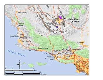
The Kern River Oil Field is a large oil field in Kern County in the San Joaquin Valley of California, north-northeast of Bakersfield in the lower Sierra foothills. Yielding a cumulative production of close to 2 billion barrels (320,000,000 m3) of oil by the end of 2006, it is the third largest oil field in California, after the Midway-Sunset Oil Field and the Wilmington Oil Field, and the fifth largest in the United States.[1] Its estimated remaining reserves, as of the end of 2006, were around 476 million barrels (75,700,000 m3), the second largest in the state. It had 9,183 active wells, the second highest in the state.[2] The principal operator on the field is Chevron Corporation[3]
Geographic setting

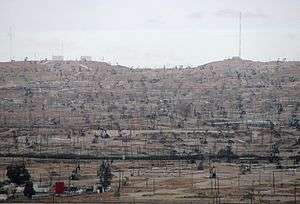
The Kern River Oil Field covers an area of 10,750 acres (43.5 km2) in a rough oval extending over the low hills north-northeast of Bakersfield, hills which are now almost completely barren except for oil rigs, drilling pads and associated equipment. This area is the densest operational oil development in the state of California: Midway-Sunset, which has more wells, is almost three times as large in surface area, for a lower overall density. Elevations on the Kern River Oil Field range from approximately 400 to 1,000 feet (300 m), rising towards the northeast, and the Kern River flows south of the field, from east to west, from the Sierra Nevada into the city of Bakersfield.
The oil field is one of many contiguous oil fields along the eastern edge of the southern San Joaquin Valley, lying between the Kern Front field to the northwest and the Kern Bluff field to the southeast, on the other side of the Kern River. Directly north of the Kern River field is the large Mount Poso Oil Field, entirely in the Sierra foothills, and to the northeast is the Round Mountain Oil Field.
Geology
Unlike some of the other Kern County oil fields which contain numerous pools, the Kern River field has one large pool, named for the field itself (the Kern River) and two smaller pools, the Vedder and Jewett, discovered in 1981 and 1985 respectively. The formation containing the Kern River pool is of Pliocene-Pleistocene age, and lies 400 to 1,300 feet (400 m) below ground surface; the Vedder and Jewett are of Oligocene and Miocene ages, respectively, with depths of 4,700 and 4,220 feet (1,290 m).[4]
The deepest well in the Kern River Oil Field was originally drilled by Standard Oil of California, and attained a depth of 6,986 feet (2,129 m) below ground surface. The granitic basement rocks were of late Jurassic age.[5]
History and operations

According to a California State Historical Marker of the original site in Kern County, "Oil was discovered at 70 feet in 1899, when Tom Means persuaded Roy Elwood and Frank Wiseman, aided by Jonathan, Bert, Jed, and Ken Elwood, George Wiseman, and John Marlowe, to dig here for oil. On June 1, 1899, 400 feet to the north, Horace and Milton McWhorter drilled this region's first commercial well."[6]
The current operator of the Kern River Field is Chevron, who has gradually acquired the field through buyout and merger with the various other operators, including Tidewater, one of the original developers of the enhanced production technologies that revived the field in the 1960s; Getty Oil; and Texaco.
While most of the oil has been removed from the field, enhanced production technologies such as steam flooding have made it possible to extract much of the oil once considered unfeasible to recover. A high price of oil also makes recovery of previously marginal pools attractive. Total estimated reserves of the Kern River field at the end of 2006 totaled more than 475 million barrels (75,500,000 m3), which represented approximately 15% of California's 3.2-billion-barrels (510,000,000 m3) reserve.[7]
Annual oil production from the field was 26.2 million barrels as of 2012.
Wastewater from the field was once allowed to drain directly into the streams dissecting the region, and thence into the Kern River. This practice ended in the 1960s and 1970s when more stringent environmental regulations were enacted both on federal and state levels. Wastewater now is treated in facilities specifically built for this purpose, and after the treatment, is used to irrigate crops in the San Joaquin Valley.[8]
References
- On-site California Historical Marker .
- California Oil and Gas Fields, Volumes I, II and III. Vol. I (1998), Vol. II (1992), Vol. III (1982). California Department of Conservation, Division of Oil, Gas, and Geothermal Resources (DOGGR). 1,472 pp. Kern River Oil Field information is on pp. 232-233. PDF file available on CD from www.consrv.ca.gov.
- California Department of Conservation, Oil and Gas Statistics, Annual Report, December 31, 2006.
Notes
- ↑ California Department of Conservation, Oil and Gas Statistics, Annual Report, December 31, 2006, p. 4
- ↑ The largest remaining reserves in California and greatest number of producing wells belong to the enormous Midway-Sunset Field in southwestern Kern County.
- ↑ California Department of Conservation, Oil and Gas Statistics, Annual Report, December 31, 2006, p. 2
- ↑ The Jewett pool was abandoned in 1987. DOGGR, California Oil and Gas Fields, p. 233
- ↑ DOGGR, California Oil and Gas Fields, p. 233
- ↑ http://www.hmdb.org/marker.asp?marker=25294
- ↑ California Department of Conservation, Oil and Gas Statistics, Annual Report, December 31, 2006, p. 2
- ↑ Kern River Field at 100: article in the Bakersfield Californian on the history of the Kern River Oil Field
External links
- 100 Years of Oil, from the Bakersfield Californian: stories about local oilfields including the Kern River
| Wikimedia Commons has media related to Kern River Oil Field. |
Coordinates: 35°27′23″N 118°59′00″W / 35.4564°N 118.9834°W