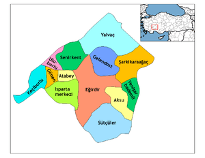
Keçiborlu
| Keçiborlu | |
|---|---|
 Keçiborlu | |
| Coordinates: TR 37°56′35″N 30°18′08″E / 37.94306°N 30.30222°ECoordinates: TR 37°56′35″N 30°18′08″E / 37.94306°N 30.30222°E | |
| Country |
|
| Province | Isparta |
| District | Keçiborlu |
| Government | |
| • Mayor | Turgut Soykan |
| Area[1] | |
| • District | 535.75 km2 (206.85 sq mi) |
| Elevation | 1,010 m (3,310 ft) |
| Population (2012)[2] | |
| • Urban | 6,924 |
| • District | 14,819 |
| • District density | 28/km2 (72/sq mi) |
| Post code | 32700 |
| Website |
www |
Keçiborlu is a town and district of Isparta Province in the Mediterranean region of Turkey. The town had 7,049 inhabitants according to 2010 census.
Etymology
The town was known as Eudoxipolis (Ευδοξίπολη in Greek) during the Roman and Byzantine periods.
History
Keçiborlu is known as the site where Atlasjet Flight 4203 crashed on November 30, 2007.
Economy
In the early 20th-century, sulphur was mined in the area.[3]
References
- ↑ "Area of regions (including lakes), km²". Regional Statistics Database. Turkish Statistical Institute. 2002. Retrieved 2013-03-05.
- ↑ "Population of province/district centers and towns/villages by districts - 2012". Address Based Population Registration System (ABPRS) Database. Turkish Statistical Institute. Retrieved 2013-02-27.
- ↑ Prothero, G.W. (1920). Anatolia. London: H.M. Stationery Office. p. 107.
External links
- District governor's official website (Turkish)
This article is issued from Wikipedia - version of the Thursday, February 05, 2015. The text is available under the Creative Commons Attribution/Share Alike but additional terms may apply for the media files.
