Karlsfeld

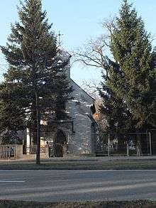
Ludl Chapel (1900) is one of the oldest still existing buildings in Karlsfeld
| Karlsfeld | ||
|---|---|---|
| ||
 Karlsfeld | ||
Location of Karlsfeld within Dachau district  | ||
| Coordinates: 48°13′N 11°28′E / 48.217°N 11.467°ECoordinates: 48°13′N 11°28′E / 48.217°N 11.467°E | ||
| Country | Germany | |
| State | Bavaria | |
| Admin. region | Oberbayern | |
| District | Dachau | |
| Government | ||
| • Mayor | Stefan Kolbe (CSU) | |
| Area | ||
| • Total | 15.55 km2 (6.00 sq mi) | |
| Population (2013-12-31)[1] | ||
| • Total | 18,949 | |
| • Density | 1,200/km2 (3,200/sq mi) | |
| Time zone | CET/CEST (UTC+1/+2) | |
| Postal codes | 85757 | |
| Dialling codes | 08131 | |
| Vehicle registration | DAH | |
| Website | www.karlsfeld.de | |
Karlsfeld is a municipality in the district of Dachau, in Bavaria, Germany. During World War II, it was the location of a subcamp of Dachau concentration camp.
The municipality is situated 12 km northwest of Munich (centre).
The headquarters of MAN and MTU Aero Engines are located in Munich right on the border to Karlsfeld.
Karlsfeld railway station is served by the Munich S-Bahn on line S2.
Twin town
External links
- Karlsfeld Official web site
Notes
- ↑ "Fortschreibung des Bevölkerungsstandes". Bayerisches Landesamt für Statistik und Datenverarbeitung (in German). 31 December 2013.
| ||||||||
|
This article is issued from Wikipedia - version of the Sunday, August 16, 2015. The text is available under the Creative Commons Attribution/Share Alike but additional terms may apply for the media files.
