Ilulissat Icefjord
| Ilulissar Icefjord
Ilulissat Kangia (Kalaallisut) Ilulissat Isfjord (Danish) | |
|---|---|
| Name as inscribed on the World Heritage List | |
|
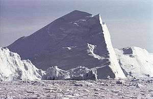
Iceberg making its way through Ilulissat Icefjord | |
| Type | Natural |
| Criteria | vii, viii |
| Reference | 1149 |
| UNESCO region | Europe and North America |
| Coordinates | 69°07′6″N 49°30′0″W / 69.11833°N 49.50000°WCoordinates: 69°07′6″N 49°30′0″W / 69.11833°N 49.50000°W |
| Inscription history | |
| Inscription | 2004 (28th Session) |
 Location in Greenland | |
Ilulissat Icefjord (Greenlandic: Ilulissat Kangerlua) is a fjord in western Greenland. Ilulissat Icefjord was declared a UNESCO World Heritage Site in 2004.
Geography
It runs west 40 km (25 mi) from the Greenland ice sheet to Disko Bay just south of Ilulissat town. At its eastern end is the Jakobshavn Isbræ glacier (Greenlandic: Sermeq Kujalleq), the most productive glacier in the Northern Hemisphere. The glacier flows at a rate of 20–35 m (66–115 ft) per day, resulting in around 20 billion tonnes of icebergs calved off and passing out of the fjord every year. Icebergs breaking from the glacier are often so large (up to a kilometer (3,300 ft) in height) that they are too tall to float down the fjord and lie stuck on the bottom of its shallower areas, sometimes for years, until they are broken up by the force of the glacier and icebergs further up the fjord. On breaking up the icebergs emerge into the open sea and initially travel north with ocean currents before turning south and running into the Atlantic Ocean. Larger icebergs typically do not melt until they reach 40-45 degrees north (further south than the United Kingdom and level with New York City).
External links
- The official website of UNESCO World Heritage Site Ilulissat Icefjord
- NASA study: Fastest Glacier in Greenland Doubles Speed
- Ilulissat Icefjord. Book edited by Ole Bennike, Naja Mikkelsen, Greg McCollum, Henrik Klinge Pedersen and Anker Weidick, Geological Survey of Denmark and Greenland, 28 September 2004, ISBN 87-7871-136-3
- Explore Ilulissat Icefjord - teaching material from GEUS
| ||||||||||||||||||||||||||
| |||||||||||||||||

