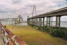
John P. Grace Memorial Bridge
- This article is about the original bridge which was demolished. For the bridge that was demolished along with it, see Silas N. Pearman Bridge. For the current bridge, see Arthur Ravenel Jr. Bridge.
| Cooper River Bridge | |
|---|---|
.jpg) Grace Memorial Bridge is on the left and the Pearman Bridge is on the right | |
| Coordinates | 32°48′7.47″N 79°55′52.73″W / 32.8020750°N 79.9313139°WCoordinates: 32°48′7.47″N 79°55′52.73″W / 32.8020750°N 79.9313139°W |
| Carries |
|
| Crosses | Cooper River and Town Creek |
| Locale | Charleston, SC |
| Official name | John P. Grace Memorial Bridge |
| Maintained by | SCDOT |
| Characteristics | |
| Design | Cantilever truss with suspended center span |
| Total length | 2.7 miles |
| Width | 20 feet (Two 10-foot lanes) |
| Height | 250 feet |
| Longest span | 1,050 feet |
| Load limit | 5 tons |
| Clearance below | 155 feet |
| History | |
| Construction begin | February 7, 1928 |
| Opened | August 8, 1929 |
| Closed | July 16, 2005 |
| Statistics | |
| Daily traffic | 35,000 |
| Toll | $0.50 per vehicle and driver and $0.15 for each additional passenger (until 1945) |
The John P. Grace Memorial Bridge, or the Cooper River Bridge as it was familiarly known, was a cantilever bridge that crossed the Cooper River in Charleston, South Carolina. It opened on August 8, 1929 and was built by the Cooper River Bridge Company. Shortridge Hardesty of Waddell & Hardesty, New York designed the bridge.[1]
The Silas N. Pearman Bridge was opened beside it in 1966 to relieve traffic. They were both replaced by the Arthur Ravenel, Jr. Bridge in 2005.
History
The ribbon was cut on August 8, 1929, at 1:12 p.m. by Col. James Armstrong, and between 30,000 and 50,000 people[2] crossed the bridge during its first day. The bridge was owned by Cooper River Bridge, Inc., a private company. President of the company was John P. Grace, former mayor of Charleston. The bridge was built by a consortium of four engineering and construction firms. Construction lasted seventeen months, and the final cost of the bridge was six million dollars, to be financed by a 50-cent toll. The bridge had two 10 ft (3.0 m) lanes. In 1946 the state bought the bridge from Cooper River Bridge, Inc. and the 50-cent toll was removed. Unfortunately the same year a freighter rammed the bridge ripping down a 240-foot (73 m) section of it. Widening occurred in 1959 for a breakdown lane. Construction on the parallel Silas N. Pearman Bridge - intended to alleviate load limits on the Grace bridge - was completed in 1966. In 1979, a 3rd lane was added to the Grace bridge at the Charleston approach. By 1979, the bridge became functionally obsolete and there were many plans to replace the bridge, but not enough money.
Replacement

In 1995 the Grace bridge scored only a 4 out of 100 (4%), or an F, in safety. Arthur Ravenel Jr. ran for SC Senate as a way to solve the problem. He planned for an 8 lane bridge to replace the Grace/Pearman spans of US 17. Construction started in 2001 and the new bridge opened in July 2005, at which point the Grace bridge closed to traffic.
Demolition
After a "Burn The Bridges" run and a parade of 1929-era cars over the empty deck, demolition of the Grace Bridge began in August 2005. There had been a movement to try to sell the bridge or to place it on the National Register of Historic Places so that, after removal, it could be reassembled elsewhere, but most of the steel and concrete was either recycled or dropped into the ocean to start artificial fishing reefs. The demolition of the Grace Bridge took approximately 2 years and required closing the shipping lane for half a day as the main span was cut from the cantilever sections and lowered onto a barge below.
In popular culture
- The old bridge most notably was utilized for filming of a scene in the 1995 film Die Hard with a Vengeance.
References
- ↑ Hardesty & Hanover timeline, 1887-1938, accessed April 26, 2007
- ↑ "50,000 Persons Cross Cooper as Bridge Is Opened". Charleston News & Courier. Aug 9, 1929. pp. A1. Retrieved October 21, 2013.
- Annan, Jason; Pamela Gabriel. The Great Cooper River Bridge. Columbia, SC: University of South Carolina Press. ISBN 1-57003-470-2.
External links
- Grace Memorial Bridge at Structurae
- Unbuilding the Grace and Pearman Bridges A series of photo essays documenting the entire demolition process by Frank Starmer and Sparky Witte
- Photographic Record of the Cooper River Bridge at the Charleston Archive at Charleston County Public Library
| |||||||||