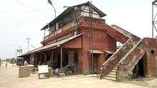
Jainagar, Bihar
| Jainagar जयनगर | |
|---|---|
| Town | |
 Jainagar Location in Bihar, India | |
| Coordinates: 26°35′33″N 86°08′14″E / 26.59250°N 86.13722°ECoordinates: 26°35′33″N 86°08′14″E / 26.59250°N 86.13722°E | |
| Country | India |
| State | Bihar |
| District | Madhubani |
| Elevation | 77 m (253 ft) |
| Population (2001) | |
| • Total | 29,487 |
| Languages | |
| • Official | Maithili, Hindi |
| Time zone | IST (UTC+5:30) |
| PIN | 847226 |
| Telephone code | 06246 |
| Vehicle registration | BR32 |
| Lok Sabha constituency | jhanjharpur |
| Vidhan Sabha constituency | Khajauli |
| Website | www.jaynagar.in |
Jainagar (Hindi: जयनगर also transliterated Jaynagar or Jayanagar) is a city and notified area in Madhubani district, Bihar State, India. It is situated on the holy Kamala River and has road and rail connections to India's main cities and to Nepal. The local language is Maithili. There are many temples in Jaynagar; the most notable are Durga Mandir (108 ft high and situated 2 km from the railway station), and Shilanath (famous for Lord Shiva) 4 km from the railway station near DB College.
Economy
Jainagar is one of the most important towns in Darbhanga-Madhubani region. Historically, this has been a regional hub of economic activities, in large parts driven by the proximity to Nepal. It had twenty some rice mills at some point which disappeared for the non-conducive government policies, of which Rajput Rice mill of Jaynagar is one of the largest rice mill in Madhubani district it also improves the economy of the Jaynagar during the period of 70's and give the employment to many people in terms of economy, The Rajput Rice Mill is founded by Shri Baldeo Singh and Shri Munsi Dayal Singh. They also established school and colleges namely Dalshingar Baldeo College (D.B. COLLEGE) which is situated 4 km from the Jainagar railway station, the establishment of D.B. College also gives the employment to the professors and to the college staffs, spreading the education to the poor people of Jainagar and near by villages of Jainagar in 80's they handover the college to the government for the development of the college, people and the area. Its connectivity by train to major metro areas like Delhi and Kolkata has further boosted its economic potential. Jainagar has attracted significant immigration from the rural areas in recent years, putting unprecedented upward pressure on real estate prices.
Health services are primarily catered by private clinics and hospitals, which are of good quality, arguably best in the district with quality of good doctors. With deployment of SSB (Seema Sashatra Bal) on the borders, the security and safety have also improved in recent years. Jainagar has basic public educational infrastructure with government schools and colleges, including a college for women. However, recent years have seen a boom in private school education, with several schools coming up. Immigration from rural areas is possibly driven by aspirations of rural class to offer improved educational opportunities to their children.
80 to 85% business of overall business is export business of cloth, footwear, chemicals, tobacco and medicine to Nepal. In recent times the villages on the bank of river Kamla has emerged as an ideal place for the cultivation of fruits and vegetables like watermelon, Pumpkin, Cucumber which has high water containts making Jaynagar a transit point and also acting as a natural market.
Transport
Jaynagar is on the Barauni–Gorakhpur, Raxaul and Jaynagar lines and well connected by broad gauge railway with the major cities of India. NH 104 and NH 105 pass through Jaynagar.

Jayanagar has a railway line to Nepal, though this is currently in poor condition and currently being renovated and extended to the interior of Nepal. This railway is only passenger line currently in service in Nepal. Nepal operates a customs checkpoint for goods, however Indian and Nepalese nationals cross without restrictions.

Now Direct Connectivity with Delhi, Kolkatta, Mumbai and Chennai all Metros.
Demographics
As of 2001 India census,[1] Jaynagar had a population of 29487. Males constitute 53% of the population and females 47%. Jaynagar has an average literacy rate of 58%, slightly below the national average of 59.5%. Male literacy is 67%, and female literacy is 48%. 16% of the population is under 6 years of age.
Culture
Often referred as holy city, Jaynagar is famous for kartik poornima in all nearby areas. Thousands of saints and devotees from India and Nepal gather on the auspicious day of poornima in kartik month of Hindu calendar and take a bath in the holy Kamla river. Also in the shraavana month people come to jaynagar and take jal from the river and pour it on the lord Shiva at Kapileshwar Sthan, 40 km from Jaynagar near the Madhubani.

Jaynagar celebrates Hindu and Muslim festivals throughout the year. One of the main festivals celebrated here is Chhath, seven days after Deepawali. Makar Sankranti (Khichdi) is celebrated on 14 January, Saraswati Puja (with grand statues), Holi (all colourful), Ram Navami, Raksha Bandhan (between brothers and sisters), Durga Puja, Diwali, Eid, and Muharram are also celebrated locally.
Teej, Chaurchan and Ghadi is one of the famous local festival .
Education
Jainagar has basic public educational infrastructure with government schools and colleges, including a college for women and separate high schools for girls and boys. Immigration from rural areas is possibly driven by aspirations of rural class to offer improved educational opportunities to their children.Jaynagar has emerged as an educational hub in the locality. Around 30 large and small schools and many private coaching centers have flourished in the city. Students from nearby villages come here to get quality education and to prepare for different grade exams and government jobs.
References
- ↑ "Census of India 2001: Data from the 2001 Census, including cities, villages and towns (Provisional)". Census Commission of India. Archived from the original on 2004-06-16. Retrieved 2008-11-01.
External links
| ||||||||||||||||||||||