Isahaya, Nagasaki
| Isahaya 諫早市 | |
|---|---|
| City | |
|
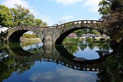
Megane Bridge of Isahaya Park | |
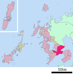
 Location of Isahaya in Nagasaki Prefecture | |
 Isahaya Location in Japan | |
| Coordinates: 32°51′N 130°4′E / 32.850°N 130.067°ECoordinates: 32°51′N 130°4′E / 32.850°N 130.067°E | |
| Country | Japan |
| Region | Kyushu |
| Prefecture | Nagasaki Prefecture |
| Government | |
| • Mayor | Akio Miyamoto (since April 2009) |
| Area | |
| • Total | 320.99 km2 (123.93 sq mi) |
| Population (March 1, 2010) | |
| • Total | 141,151 |
| • Density | 439/km2 (1,140/sq mi) |
| Symbols | |
| • Tree | Euonymus hamiltonianus |
| • Flower | Rhododendron |
| Time zone | Japan Standard Time (UTC+9) |
| City Hall Address | 854-8601 |
| Website |
www |
Isahaya (諫早市 Isahaya-shi) is a city located in Nagasaki Prefecture, Japan. The city was founded on September 1, 1940.
As of March 2008, the city has an estimated population of 141,151 and a population density of 439 persons per km². The total area is 320.99 km².
On March 1, 2005, the towns of Tarami, Moriyama, Iimori, Takaki and Konagai (all from Kitatakaki District) were merged to create the new and expanded city of Isahaya. The city was once part of Kitatakaki District, but due to this merger, the district has no more municipalities left and the district was officially dissolved as a result of this merger.
Sister City relations
External links
 Media related to Isahaya, Nagasaki at Wikimedia Commons
- Isahaya City official website (Japanese)
| ||||||||||||||||||||||||||||
|
This article is issued from Wikipedia - version of the Wednesday, December 16, 2015. The text is available under the Creative Commons Attribution/Share Alike but additional terms may apply for the media files.
