Indiana State Road 246
| ||||
|---|---|---|---|---|
 | ||||
| Route information | ||||
| Maintained by INDOT | ||||
| Length: | 37.89 mi[1] (60.98 km) | |||
| Major junctions | ||||
| West end: |
| |||
|
| ||||
| East end: |
| |||
| Location | ||||
| Counties: | Clay, Owen, Vigo | |||
| Highway system | ||||
| ||||
State Road 246 is an east–west road in the southwest portion of the U.S. state of Indiana.
Route description
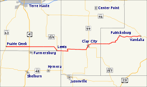
State Road 246 begins in the small town of Prairie Creek at State Road 63. Going east, it crosses U.S. Route 41 just north of Farmersburg. It veers slightly south in order to pass through Lewis where it is concurrent with State Road 159, then jogs north again to hit Middlebury and Clay City where it is concurrent with State Road 59. Continuing east, it winds to the northeast to pass through Patricksburg, then runs directly east to State Road 46 at Vandalia.
State Road 46, its parent route, angles northwest to Terre Haute from Vandalia, whereas State Road 246 goes west.
Major intersections
| County | Location | mi[1] | km | Destinations | Notes |
|---|---|---|---|---|---|
| Vigo | Prairie Creek Township | 0.00 | 0.00 | Western terminus of SR 246 | |
| Linton Township | 5.85 | 9.41 | |||
| Lewis | 13.19 | 21.23 | Western end of SR 159 concurrency | ||
| Clay | Lewis Township | 14.87 | 23.93 | Eastern end of SR 159 concurrency | |
| Clay City | 21.49 | 34.58 | Southern end of SR 59 concurrency | ||
| Northern terminus of SR 157 | |||||
| 23.00 | 37.01 | Northern end of SR 59 concurrency | |||
| Owen | Vandalia | 37.89 | 60.98 | Eastern terminus of SR 246 | |
1.000 mi = 1.609 km; 1.000 km = 0.621 mi
| |||||
References
- 1 2 "INDOT Roadway Referencing System" (PDF).
External links
This article is issued from Wikipedia - version of the Tuesday, November 11, 2014. The text is available under the Creative Commons Attribution/Share Alike but additional terms may apply for the media files.
