Hopkins, Belize
Coordinates: 16°52′0″N 88°17′0″W / 16.86667°N 88.28333°W
| Hopkins | |
|---|---|
| Village | |
|
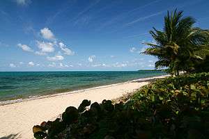
Hopkins Beach, Stann Creek, Belize | |
 Hopkins | |
| Coordinates: 16°52′N 88°17′W / 16.867°N 88.283°W | |
| Country |
|
| District | Stann Creek District |
| Time zone | Central (UTC-6) |
| Climate | Af |
Hopkins Village is a coastal village in eastern Belize.
Hopkins is a Garifuna village on the coast of the Stann Creek District in Belize. Hopkins is considered by some Belizeans to be the cultural center of the Garifuna population in Belize. The town hosts its own national holiday, Hopkins Day, and welcomes people for their celebration on Garifuna Independence Day as well, they do this with drum ceremonies that can last till early hours in the morning.
The village is separated into two parts; the Northside (Baila) and the Southside (False Sittee). Hopkins is surrounded by the Maya Mountains and the Cockscomb Range inland, and the Caribbean Sea on its shore. It is also very close to the Sittee River. The village was created in 1942 to replace the village of Newtown, which was devastated by a hurricane further up the coast.
Today Hopkins is a small but vibrant community of approximately 1,000 villagers. The people live mostly by farming and fishing, and more recently many have found work in the growing tourist industry. The residents are known for their friendliness and genuine hospitality, and welcome visitors to their village. Hopkins has a selection of gift shops, restaurants and small bars. Hopkins was recently voted "The Friendliest Village in Belize" by Belize First Magazine.
External links
| Wikimedia Commons has media related to Hopkins, Belize. |
