Honjō, Saitama
| Honjō 本庄市 | ||
|---|---|---|
| City | ||
| ||
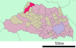
 Location of Honjō in Saitama Prefecture | ||
 Honjō Location in Japan | ||
| Coordinates: 36°14′36″N 139°11′25″E / 36.24333°N 139.19028°ECoordinates: 36°14′36″N 139°11′25″E / 36.24333°N 139.19028°E | ||
| Country | Japan | |
| Region | Kanto | |
| Prefecture | Saitama Prefecture | |
| Government | ||
| • Mayor | Shinge Yoshida (since July 2005) | |
| Area | ||
| • Total | 89.71 km2 (34.64 sq mi) | |
| Population (May 1, 2011) | ||
| • Total | 81,267 | |
| • Density | 905.89/km2 (2,346.2/sq mi) | |
| Symbols | ||
| • Tree | Osmanthus | |
| • Flower | Oenothera tetraptera (Tsukimiso in Japanese) | |
| Time zone | Japan Standard Time (UTC+9) | |
| City Hall Address |
3-5-3 Honjo, Honjo-shi, Saitama-ken 367-8501 | |
| Website |
www | |
Honjō (本庄市 Honjō-shi) is a city in Saitama Prefecture, Japan. The city was founded on July 1, 1954.
As of May 1, 2011, the city has an estimated population of 81,267, with 32,685 households and a population density of 905.89 persons per km². The total area is 89.71 km2 (34.64 sq mi).
On January 10, 2006, the town of Kodama (from Kodama District) was merged into Honjō.
Transportation
- Honjō Station (JR East Takasaki Line)
- Honjō-Waseda Station (JR East Jōetsu Shinkansen)
- National Road Route 17
Education
International schools:
- Escola Intercultural Unificada Arco Íris - Brazilian school[1]
Previously the city hosted another Brazilian school, Centro de Aprendizagem Logos.[2]
Entertainment
- Honjō Circuit, a small motorsports circuit
International relations
Twin towns — Sister cities
Honjō is twinned with:
-
 Kazo, Saitama, Japan
 -
 Shibukawa, Gunma, Japan
References
- ↑ "Escolas Brasileiras Homologadas no Japão" (Archive). Embassy of Brazil in Tokyo. Retrieved on October 13, 2015.
- ↑ "Escolas Brasileiras Homologadas no Japão" (Archive). Embassy of Brazil in Tokyo. February 7, 2008. Retrieved on October 13, 2015.
External links
- Official website (Japanese)
| |||||||||||||||||||||||||
|
This article is issued from Wikipedia - version of the Thursday, November 05, 2015. The text is available under the Creative Commons Attribution/Share Alike but additional terms may apply for the media files.