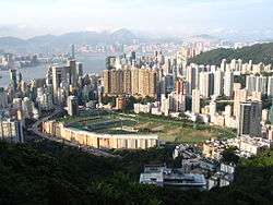
Happy Valley Racecourse
 | |
| Location | Wan Chai District, Hong Kong |
|---|---|
| Owned by | Hong Kong Jockey Club |
| Date opened | 1845 |
| Course type | Thoroughbred |
| Official website | |
Happy Valley Racecourse (Chinese: 跑馬地馬場 or 快活谷馬場) is one of the two racecourses for horse racing and is a tourist attraction in Hong Kong. It is located in Happy Valley on Hong Kong Island, surrounded by Wong Nai Chung Road and Morrison Hill Road.
The capacity of the venue is 55,000.[1]
History
| Happy Valley Racecourse | |||||||||||||||||
|
Westerly panorama of Happy Valley Racecourse | |||||||||||||||||
 Happy Valley Racecourse at night | |||||||||||||||||
| Traditional Chinese | 快活谷馬場 | ||||||||||||||||
|---|---|---|---|---|---|---|---|---|---|---|---|---|---|---|---|---|---|
| |||||||||||||||||
| Alternative Chinese name | |||||||||||||||||
| Traditional Chinese | 跑馬地馬場 | ||||||||||||||||
| |||||||||||||||||

It was first built in 1845 to provide horse racing for the British people in Hong Kong. Before it was built, the area was a swampland, but also the only flat ground suitable for horse racing on Hong Kong Island. To make way for the racecourse, Hong Kong Government prohibited rice growing by villages in the surrounding area. The first race ran in December 1846. Over the years, horse racing became more and more popular among the Chinese residents.
On 26 February 1918, there was a fire and at least 590 people died. By the next day as many as 576 confirmed deaths were reported by the Hong Kong Telegraph.[2] It was caused by the collapse of a temporary grandstand, which knocked over food stalls and set bamboo matting ablaze.[3] It is a fire with one of the highest casualties in Hong Kong history.
The race track was rebuilt in 1995, and became a world-class horse racing facility.
Facilities
The Happy Valley Racecourse is one of two racecourses in Hong Kong used by the Hong Kong Jockey Club for horse racing meets, the other being the Sha Tin Racecourse. Races in Happy Valley usually take place on Wednesday nights[4] and are open to the public as well as members of the Club.[5] The Happy Valley Racecourse and its seven-storey stands are capable of accommodating approximately 55,000 spectators.[6]
The inner field of the course contains sports and leisure facilities such as football, hockey and rugby fields, managed by the Leisure and Cultural Services Department.[7]
The Hong Kong Jockey Club Archive and Museum
The Hong Kong Jockey Club Archive and Museum (or Hong Kong Racing Museum) was set up in 1995 and opened on 18 October 1996.[8] It is now located on the second floor of the Happy Valley Stand of the racecourse.
There are four galleries in the museum:
- The Origin of Our Horses: Shows the migration route horses travelled in the early days from the northern part of China to Hong Kong.
- Shaping Sha Tin: Exhibits the history of construction of Sha Tin Racecourse.
- Understanding Horses: Exhibits the skeleton of the three-time Hong Kong Champion Silver Lining.
- Thematic Exhibitions: The history of the Jockey Club is exhibited. Selected charitable organizations and community projects supported by the Hong Kong Jockey Club Charities Trust are also displayed in this gallery.
There is also a cinema and a souvenir shop in the museum.
See also
References
- ↑ http://www.thestar.com/life/travel/2012/03/23/horse_racing_at_happy_valley_lives_up_to_hype.html
- ↑ Bard, Solomon. [2002] (2002). Voices from the Past: Hong Kong, 1842-1918. Hong Kong University Press. ISBN 962-209-574-7.
- ↑ Lai, Kam-biu, Bill, "Policy analysis and policy windows: fire fighting policy in Hong Kong", Appendix V, University of Hong Kong, 1999
- ↑ DeWolf, Christopher "9 Hong Kong tourist traps -- for better or worse" CNN Go. 27 October 2010. Retrieved 2012-03-03
- ↑ "Happy Valley Racecourse" HKJC Co. Retrieved 2012-03-04
- ↑ Montague, Trout "Horse Racing at the Hong Kong Jockey Club" BBC Retrieved 2013-09-17
- ↑ "Happy Valley Recreation Ground" LCSD. Retrieved 2012-03-04
- ↑ "The Hong Kong Jockey Club Archive and Museum"
External links
| Wikimedia Commons has media related to Happy Valley Racecourse. |
| ||||||||||||||||||||||||||
Coordinates: 22°16′22″N 114°10′56″E / 22.27278°N 114.18222°E
