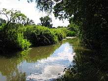
Holy Brook


The Holy Brook is a channel of the River Kennet in the vicinity of the English town of Reading, Berkshire. While of considerable historical significance, the origin and nature of the brook is still unclear. It is probable that some parts of the channel are natural, while other parts were created in mediaeval times to supply water to water mills and fish ponds.[1]
The Holy Brook leaves the main channel of the Kennet at a structure known as Arrowhead near the village of Theale, and flows to the north of the main channel until rejoining the main channel in the centre of Reading, adjacent to the site of Reading Abbey. The channel is some 6 miles (9.7 km) in length. Along the way it served two water mills, Calcot Mill and Abbey Mill, both of which originally belonged to the abbey.[1][2]
For the first stretch of its route, the channel forms the boundary between the Reading suburbs of Beansheaf Farm, Fords Farm, Calcot, Southcote, Coley Park and Coley to the north and the Kennet water meadows to the south. In this area the channel gives its name to the nearby civil parish of Holybrook.[1][2]
Once past Coley Park the Holy Brook enters the centre of Reading and is culverted for several stretches, only showing itself intermittently. The channel can clearly be seen where it flows under one of the entrances to the Oracle shopping centre, and also where it passes under Reading Central Library. In this area the Holy Brook has given its name to the 'Holy Brook Mall', the lower of the two enclosed shopping malls within the Oracle centre.[1]
At its eastern end, the Holy Brook formed the southern boundary of Reading Abbey, driving the Abbey's mill and supplying water to its necessarium. It re-entered the main channel of the River Kennet immediately to the south of the Abbey church.[3]
References
| Wikimedia Commons has media related to Holy Brook. |
Bibliography
- Sowen, Adam; Castle, Sally; Hay, Peter (2003). The Holy Brook or The Granators Tale. Two Rivers Press. ISBN 1-901677-34-6.
- Slade, Cecil (2001). The Town of Reading and its Abbey. MRM Associates Ltd. ISBN 0-9517719-4-9.
Coordinates: 51°27′20″N 0°57′55″W / 51.4556°N 0.9653°W