Hodh Ech Chargui Region
| Hodh ech Chargui ولاية الحوض الشرقي | |
|---|---|
| Region of Mauritania | |
 | |
| Country |
|
| Departments | |
| Capital | Néma |
| Area | |
| • Total | 182,700 km2 (70,500 sq mi) |
| Population (2013 census) | |
| • Total | 430,668 |
| • Density | 2.4/km2 (6.1/sq mi) |
| ISO 3166 code | MR-01 |
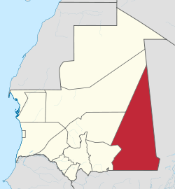
Hodh Ech Chargui (Arabic: ولاية الحوض الشرقي) is a large region in eastern Mauritania, with an area of 182,700 km2. Its capital is Néma, but the largest town, in Bassiknou Department, is Vassale at the extreme southeast of Mauritania, with 65,927 inhabitants at the 2013 Census. The region borders the Mauritanian regions of Adrar, Tagant and Hodh El Gharbi to the west and Mali to the east and south. The Aoukar basin, which formerly gave name to the greater region, is located in the southwestern part of Hodh El Gharbi.[1]
Departments

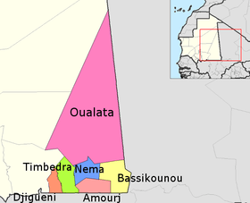
Hodh Ech Chargui is divided into seven departments, listed below with their area and populations at the 2013 Census:
| Name | Area (km2) | Population at Census 25 March 2013 [2] |
|---|---|---|
| Amourj | 9,200 | 94,559 |
| Bassiknou | 16,500 | 88,432 |
| Djiguenni | 3,900 | 59,614 |
| Néma | 10,000 | 87,048 |
| Oualata | 134,000 | 13,086 |
| Timbédra | 9,100 | 79,069 |
| N'Beiket Lehwach | * | 8,860 |
- * New department, area unknown.
Population
Hodh Ech Chargui (or Hodh el Sharqui) is the most populous of Mauritania's regions (outside of the city of Nouakchott). The Census enerated on 25 March 2013 found 430,668 people living in Hodh Ech Chargui. The region sees many travelers going through to Mali, either south through Bassiknou to Bamako or east to Timbuktu. The major population centers are far-spread and many people fall under the poverty level, making it easy for extremist groups like Al-Qaeda in the Islamic Maghreb to infiltrate and work.
See also
- Regions of Mauritania
- Districts of Mauritania
References
| ||||||||||||
Coordinates: 19°00′N 7°15′W / 19.000°N 7.250°W